
Summit, IL (SMT)
Located about 13 miles southwest of downtown Chicago, Summit occupies a barely perceptible ridge that effectively separates the watersheds of the Mississippi River and the Great Lakes.
Archer Avenue and South Center Avenue
Summit, IL 60501
- Facility Ownership: Metra
- Parking Lot Ownership: Metra
- Platform Ownership: Canadian National Railway Company (CN) Illinois Central (IC) (A subsidiary of CN)
- Track Ownership: Canadian National Railway Company (CN) Illinois Central (IC) (A subsidiary of CN)
Marty Sandoval
Regional Contact
governmentaffairschi@amtrak.com
For information about Amtrak fares and schedules, please visit Amtrak.com or call 1-800-USA-RAIL (1-800-872-7245).
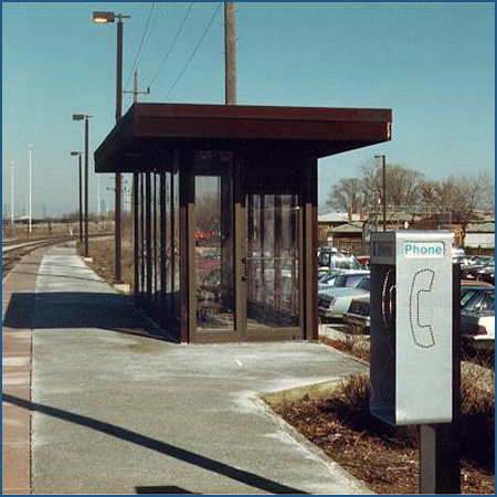
The Summit station is roughly 13 miles southwest of downtown Chicago and is a stop on Amtrak’s Lincoln Service connecting Chicago with St. Louis, as well as Metra’s commuter rail “Heritage Corridor.” The station consists of a modest shelter structure with expansive walls of glass that are capped by a flat, cantilevered roof.
Contrary to its name, Summit does not sit on a prominent hilltop or an imposing mountain; rather, it occupies a very strategic, barely perceptible ridge that was instrumental to Chicago’s tremendous growth from the mid-19th century onward. Formed by the movement of glaciers during the last Ice Age, the rise in the land effectively separates the watersheds of the Mississippi River and the Great Lakes; therefore, it has been an important portage for many centuries. On the east side of the ridge, the Chicago River originally flowed to Lake Michigan, and the nascent village of Chicago grew up where the river emptied into the lake. On the west side of the ridge, the waters of the Des Plaines River run to the Illinois River and ultimately empty into the Gulf of Mexico.
Depending upon the rains, the water level of the swampy area around Chicago would rise and fall, such that the distance between the Chicago and Des Plaines Rivers might be shortened to only a few miles. Known and used by regional American Indian groups such as the Fox, Miami, Patawatami, Illinwek, and Chippewa, the portage was recognized by early European explorers such as Frenchmen Louis Jolliet and Pere Jacques Marquette who understood its immense value to transportation in eastern North America.
Jolliet was a cartographer and fur trader who possessed a strong understanding of geography and topography. In 1673, he and Jesuit missionary Pere Marquette set out on an expedition to explore the Mississippi River; based on American Indian descriptions, they believed that the watercourse led to the Pacific Ocean. The duo and five other men sailed as far south as the intersection of the Arkansas River before they realized that they were headed to the Gulf of Mexico and territory controlled by the Spanish Empire. Turning back, the party took the advice of American Indian groups and decided to travel up the Illinois River, over the Chicago Portage, and down the Chicago River to Lake Michigan. At the time, the explorers remarked on the desirability for a canal to link the opposite flowing rivers, but that would remain a dream for another two centuries.
Illinois became a state in 1818 and the possibilities of its rich farmlands attracted Americans from the east as well as immigrants. Between 1795 and 1833, the Federal government signed a number of treaties with regional American Indian groups that eventually pushed existing tribes to the west and opened up land for settlement by European-Americans. The Treaty of Chicago, signed in 1833, was quickly followed by the founding of a town by the same name on the shore of Lake Michigan.
The growing region required transportation connections. To access the southwest and the fertile Illinois River Valley, pioneers began using the Chicago Portage, and a stagecoach line was established along one of the old American Indian paths. The area was known as “Summit” by the early 1830s, an indication that settlers understood the topological importance of the site. One of the first residents was Russell Heacock, a lawyer and the owner of an inn that served as a stagecoach stop.
The opening of the Erie Canal in 1825 spurred similar transportation improvement efforts across the nation in an attempt to better connect regions and promote trade and settlement. To assist in canal building, in 1827 the Federal government gave the state of Illinois more than 300,000 acres of land that could be sold to raise funds for a waterway. Surveying began soon thereafter but construction of the 97 mile Illinois and Michigan Canal did not begin until 1835, and was not completed until 13 years later. When in full operation, the canal linked Chicago with Peru, an Illinois River town in the north central part of the state. The passage became the last link in a water-based transportation route that connected New York City with New Orleans via the Erie Canal, Great Lakes, and the Mississippi River.
Frontier goods such as grain and lumber could be sent east or south and exchanged for finished goods from the country’s burgeoning industrial centers, particularly on the East Coast. Towns sprung up along the waterway to provide travelers with sleeping and eating accommodations, and many became local business centers. Summit expanded in the area where the Amtrak station now stands, bookended by the canal to the west and the stagecoach lines to the east; laborers who had worked on the canal, including Irish and German immigrants, remained in the community. The town became known for its vegetables which were shipped to fast growing Chicago. Quarries across the Des Plaines River provided stonework for the canal locks and they were later mined to supply building materials to nearby towns; stone was also burned to create lime for cement production.
The Illinois and Michigan Canal enjoyed a few years of dominance before its primary rival—the railroad—arrived on the scene. The first company to lay tracks through Summit was the Joliet and Chicago Railroad which was chartered in 1855 and in operation between the two namesake cities by the end of the following year. The builders wisely paralleled the right-of-way of the canal to ensure that the railroad reached established towns. It was then leased by the Chicago and Mississippi Railroad in order to provide a direct line between Bloomington and Chicago. At Bloomington, a connection was made to the Alton and Sangamon Railroad which had been chartered in 1847 to link the Mississippi River port of Alton with the state capital; by 1854, tracks had been laid beyond Springfield to Bloomington to make the eventual link with the Chicago and Mississippi Railroad.
After a series of reorganizations in the early 1860s, the full line between the Lake Michigan and Mississippi River ports became known as the Chicago and Alton Railroad—Alton Route for short. The name remained in use well into the 20th century, and the Alton system eventually linked Chicago, St. Louis, and Kansas City. Diverting business away from the neighboring waterway, the line carried coal, mail, freight, and perishable goods. The Alton also became a pioneer in the realm of passenger service. It was the first railroad to offer sleeping and dining cars, initiatives that made rail travel more comfortable and efficient.
Few historic images or descriptions remain of the Chicago and Alton depot at Summit. It was demolished in the late 20th century but stood in the vicinity of the Amtrak stop. From old photos, the depot appears to have been a two-story wood frame structure. A gabled roof formed a deep eave that protected passengers from inclement weather. The clapboard covered walls featured trim around the doors and windows that was painted in a contrasting color. Trackside, a cross-gable formed the crown of a central projecting bay; from its windows on all three sides, the station master could see down the tracks and monitor rail traffic. The station also contained a telegraph office and served as a post office distribution point.
During the next half century, Summit would gain three additional rail connections provided by the Indiana Harbor Belt, Michigan Central, and Baltimore and Ohio Chicago Terminal railroads. Chicago quickly became the epicenter of transcontinental railroading, and towns such as Summit found themselves in a good position to exploit transportation connectivity. Chicago was host to dozens of railroads, but the growing city and increasingly limited space within its boundaries created congestion on the rail lines. Speculators looked to areas outside of the city to build larger facilities such as rail yards and maintenance shops. In the 1880s, an attempt was made to build a clearing yard south of Summit where train cars could be sorted to create consists specified by destination. The effort did not succeed, but the idea remained, and the area became known as “the Clearing.”
Revived a decade later, the clearing yard was designed to be expanded as needed if rail traffic should increase. The chosen parcel was situated between the Indiana Harbor Belt Railroad and Belt Railway rights-of-way. The “belt” railways were very much what their names imply: they wrapped around the perimeter of the city like a belt and connected with the various rail lines heading towards downtown. Freight trains could avoid the congestion of downtown by using the belt railroads to skirt the urban core. Large railroads often owned stock in a belt railroad, ensuring that many companies could use the infrastructure.
When it was finished in the mid-1910s, the Clearing Yards could accommodate roughly 12,400 stationary cars, and 400 cars an hour could be sorted into new consists. The facility was known as a “hump” yard because cars were pushed over a mound or “hump” and subsequently guided by gravity onto the correct track, saving energy and manpower. A large locomotive repair facility, roundhouse, and storehouse were located nearby. A century later, the Belt Railway’s Clearing Yards cover approximately 786 acres with more than 250 miles of track. With the ability to sort 8,400 cars a day, the facility remains one of the largest and busiest in North America.
Excellent rail connections also spurred the growth of large industrial enterprises. Summit offered rail links as well as water infrastructure. The Illinois and Michigan Canal had ceased operations in the face of the railroads, but in 1900, the Sanitary and Ship Canal was completed. Similar to its predecessor, the enlarged channel linked metropolitan Chicago with Lockport on the Des Plaines River. The canal not only made shipping easier, but in one of the great engineering feats of the century, it acted as one piece of a larger water control system that reversed the flow of the Chicago River in order to drain sewage and pollutants west and away from the lakefront. In the second half of the 20th century, much of the former canal bed on the north side of Summit was filled in to make way for the Stevenson Expressway, now Interstate 55.
The first industry to locate in the Clearing district—the Corn Products Refining Company—remains today. It moved to the area from New Jersey in 1906 and commenced construction on a plant south of Summit where it produced syrups, starches, and cooking oils. The area became known as Argo after one of the company’s products. The business essentially had to create its own town to house and attract workers. East of the plant, a community of single family homes was built with a small commercial district. The company also convinced the local streetcar company to extend its line down 63rd Place to accommodate laborers commuting from Chicago.
Industrial enterprises near Summit attracted immigrant labor, and the street grid expanded to allow new housing for arrivals from Poland, Lithuania, Ireland, Italy, and Eastern Europe. Argo was annexed to Summit in 1911, but locals still refer to both areas by their separate names—Summit refers to the area north of 59th Street while the blocks to the south up to the Clearing Yards are thought of as Argo.
Summit remains a manufacturing center with the renamed Corn Products International as its cornerstone. In recent decades, the town has also gained a sizable Hispanic population, an appropriate addition to a community known for its cultural diversity. Ample public transportation options link the city to greater Chicago and its many recreational, cultural, and historic attractions. Those interested in the “Windy City’s” humble beginnings may cross the Sanitary and Ship Canal to visit Chicago Portage National Historic Site. Located in a forest preserve, the park features a 20 foot high statue that depicts Pere Marquette, Louis Jolliet, and their American Indian guide. To the southwest, the remaining portions of the canal are part of a National Heritage Corridor and a state park; interpretive centers and historic sites along the towpath explore the role of the canal in local, regional, and national history.
The Lincoln Service is supported through funds made available by the Illinois Department of Transportation.
Platform with Shelter
Features
- ATM not available
- No elevator
- No payphones
- No Quik-Trak kiosks
- No Restrooms
- Unaccompanied child travel not allowed
- No vending machines
- No WiFi
- Arrive at least 30 minutes prior to departure
Baggage
- Amtrak Express shipping not available
- No checked baggage service
- No checked baggage storage
- Bike boxes not available
- No baggage carts
- Ski bags not available
- No bag storage
- Shipping boxes not available
- No baggage assistance
Parking
Accessibility
- No payphones
- Accessible platform
- No accessible restrooms
- No accessible ticket office
- No accessible waiting room
- No accessible water fountain
- No high platform
- No wheelchair
- Wheelchair lift available
Hours