
Providence, RI - Amtrak/MBTA Station (PVD)
Located at the base of the statehouse grounds, the current station, opened in 1986, is the city's third major passenger rail facility. An elegant, shallow dome hovers over the waiting room.
Amtrak/MBTA Station
100 Gaspee Street
Providence, RI 02903
- Facility Ownership: Amtrak
- Parking Lot Ownership: N/A
- Platform Ownership: Amtrak
- Track Ownership: Amtrak
Margaret Clark
Regional Contact
governmentaffairsnyc@amtrak.com
For information about Amtrak fares and schedules, please visit Amtrak.com or call 1-800-USA-RAIL (1-800-872-7245).
Located at the base of the beautifully landscaped statehouse grounds, the Providence station is watched over by the “Independent Man,” a gilded bronze statue that surveys the city from its perch atop the capitol’s gleaming white marble dome. The station is conveniently accessed from the government center on Smith Hill, the residential and educational areas on College Hill, and the revitalized downtown business district.
Travelers at Providence can board the high-speed Acela or Northeast Regional trains to head toward Washington, D.C., or Boston. The station is also served by Massachusetts Bay Transportation Authority commuter rail that runs between Boston South Station and Wickford Junction via T.F. Green International Airport.
In summer 2019, U.S. Senator Jack Reed of Rhode Island, joined by officials from the Rhode Island Department of Transportation (RIDOT) and Amtrak, announced a $25 million funding package to begin a major renovation of the Providence station. It includes a $12.5 million grant to RIDOT from the Federal Railroad Administration (FRA) under its State of Good Repair Program designed to help repair and rehabilitate railroad infrastructure around the country. The federal investment was matched by $7.25 million from Amtrak and $5.25 million from RIDOT. This new round of investment builds upon federal funding Senator Reed had previously secured: $5.2 million for enhancements and $3 million for planning, design and environmental reviews.
The renovation project will add interior space to the station by enclosing a triangular outdoor patio near the clock tower, make better use of existing space within the building, expand and upgrade bathrooms, repair parts of the roof and improve pedestrian access. Ultimately, these enhancements will support growing ridership.
In 2015, RIDOT upgraded the station’s south entrance for the better circulation of vehicles, buses and taxis. Improved amenities for bicyclists, updated signage and landscaping were completed the next year, and repairs were also made to damaged concrete and limestone on the building façade.
The current Providence station is the third major passenger rail facility to serve the residents of this Rhode Island city. Opened to the public in 1986, the building was financed with federal funds made available through the Northeast Corridor Improvement Project (NECIP). The renowned architecture and planning firm of Skidmore, Owings, and Merrill (SOM)—designer of the Sears Tower (now Willis Tower) in Chicago—was hired to oversee various aspects of the NECIP. A “Stations Program” was established to focus efforts on the rehabilitation or construction of passenger rail facilities. SOM’s Marilyn Jordan Taylor, who specialized in urban design and transportation related projects, was appointed director of design for the Stations Program, and she is credited with drawing up plans for the Providence facility.
As discussion moved forward on upgrades in the Providence area, it was finally decided to realign the tracks and bury a portion of the right-of-way in order to free up downtown land for redevelopment. This decision meant that the old Union Station on Exchange Terrace would no longer be needed for passenger rail use and a new station could be built that would better fit travelers’ needs.
Taylor created a station design that paid homage to its important and dignified neighbors, particularly the statehouse, which was designed by McKim, Mead and White, the preeminent architectural firm of the American Renaissance. In deference to the capitol’s formal white Georgia marble exterior, the one-story concrete station was clad in a veneer of stone blocks laid in a coursed ashlar pattern. Subtle detailing includes a base of granite in a soft red tone that complements the stone’s light grey and beige coloring. Incised bands near the base and the parapet create strong shadow lines that give the impression of a watertable and belt courses, thereby reinforcing the building’s horizontal massing.
From the main entrance on Railroad Street, the station is approached via a gracious terraced plaza that creates a grand sense of arrival for those advancing on foot. Landscaped planters containing trees and shrubbery add a touch of greenery and softness to the stone and concrete surfaces while also acting as the walls for ramps leading to a parking garage beneath the plaza. Railroad Street acts as an entry drive to the station and allows travelers to be dropped off or picked up at the front of the building.
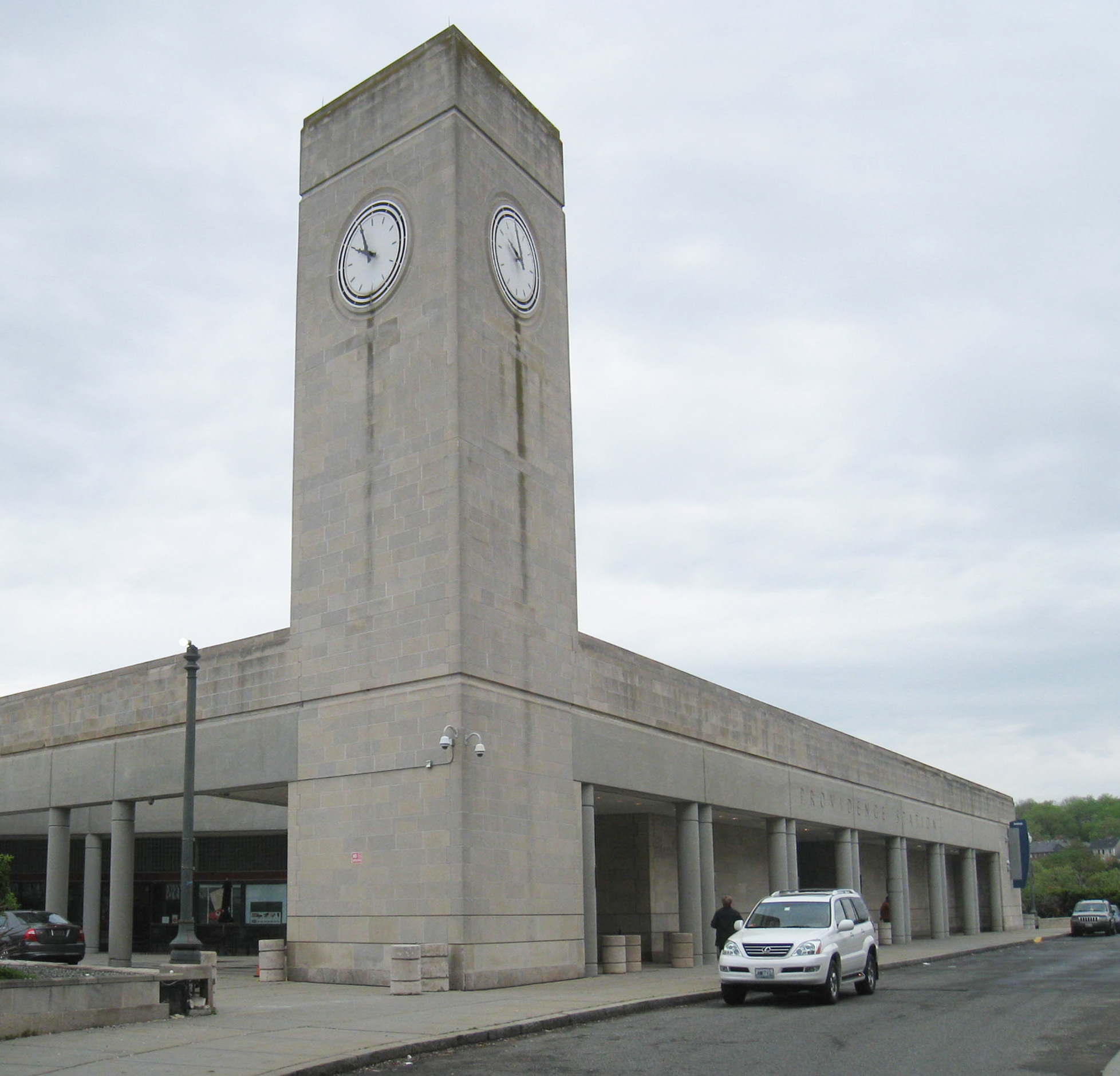
A colonnade composed of paired columns runs across the main façade, offering a bit of shelter against inclement weather such as rain and snow. At the southern end, the colonnade leads to a clock tower, a design move that recalls stations large and small that were built across the country during the 19th and 20th centuries. The columns and the clock tower emphasize the vertical axis, creating a pleasing contrast to the station’s assertive horizontal lines. Reflecting the overall outline of the building—a trapezoid—the clock tower is not squared, but rather employs obtuse and acute angles. It therefore displays two clock faces towards the front—one is clearly visible to pedestrians approaching through the plaza, while the other is angled towards those coming up Railroad Street.
Inside, a shallow dome seems to effortlessly hover over the waiting room, an effect enhanced by the placement of lighting at its base. At the center of the dome is an oculus that draws comparisons to the classical architecture of the ancient world, such as the Pantheon. Ample sunlight enters the interior through the oculus and large floor-to-ceiling windows while transoms composed of glass block help to diffuse and soften it, thereby adding warmth to the tile and stonework. As their trains approach, passengers descend to the lower level for boarding.
Located where the Moshassuck and Woonasquatucket Rivers meet to form the Providence River, which then flows into Narragansett Bay, Providence was founded as a refuge for those not welcome within the religious communities of the Puritan-led Massachusetts Bay Colony, centered at Boston. Prior to the arrival of European colonists in 1636, the land at the confluence of the rivers was a marshy cove ringed by wetlands that supported migratory birds, fish, shellfish and other animals, and attracted members of various American Indian tribes for seasonal hunting.
The town of Providence was founded by Roger Williams, a London-born preacher. Two years after graduating from Pembroke College at Cambridge University, Williams was ordained as a minister in the Church of England but grew unhappy with the church’s practices. In 1631, Williams decided to move to North America where many Puritans, who sought to “purify” the church of any remaining Roman Catholic traditions and theology, had settled in what is now eastern Massachusetts.
Williams did not concur with the Puritan leaders on all matters, and thus began a period in which he and his wife moved between various towns, including Salem and Plymouth. During this time, he also took up trade with the Wampanoag and Narragansett American Indians, forging links that would serve him well in the years to come. By fall of 1635, Williams had worn out his welcome in the Massachusetts Bay Colony, and he was faced with deportation. To avoid arrest, Williams fled westward during the winter. With the help of Wampanoag friends, he survived the bitter cold and settled on the Seekonk River, east of current-day Providence. By the spring of 1636, some of Williams’ followers had joined him in building up a village, but they were soon informed that they were trespassing on territory belonging to the Plymouth Colony.
After a further search of the land, the party decided to settle on the cove where the rivers met and where a freshwater spring was found. The first houses were built at the base of College Hill, with the current North and South Main Streets forming the spine of the village. Thankful for the “providence” that God had shown upon him, Williams gave the town its name, and envisioned the community as a “shelter for persons distressed for conscience.” Negotiating a deal with the Narragansett, Williams gained title to the land in exchange for access to English-made goods.
Each household received a strip of land on College Hill, as well as a tract south of the cove to be used for agriculture. The allotments were of uniform size, denoting the equality present within the early town. Heads of household gathered periodically to consider issues of civic importance, and each individual was free to pursue his or her own religious beliefs. The bonds established with various American Indian groups were strong, but they eventually unraveled due to forces beyond Williams’ control. During King Phillip’s War between the English and regional American Indian tribes, Providence was burned to the ground by the Narragansett in 1676.
In the mid-18th century, Providence developed as a maritime center, and its inland site provided important trade links with towns in Massachusetts. Port facilities south of the cove accommodated ships participating in the “Triangle trade,” which brought rum, sugar and enslaved people from the Caribbean as well as finished goods from Great Britain. On the eve of the Revolutionary War, the town had 4,321 residents and supported an industrial base that included distilleries, candle works, tanneries and trades such as silversmithing. Shipbuilding was carried out on the west side of the Providence River.
Education also became important to the town’s identity. Founded as the College of Rhode Island in 1764, Brown University moved to Providence in 1770 and received its current name in 1804 in recognition of a generous monetary gift bestowed upon the school by Providence businessman Nicholas Brown. In keeping with Rhode Island’s beginnings, the school welcomed students from all religious backgrounds. University Hall, the school’s oldest building, was erected in 1770 and stands on the College Green. During the Revolutionary War, it was used as a barracks and military hospital by the patriots, as the town avoided occupation by the British.
English immigrant Samuel Slater revolutionized American manufacturing in the 1790s when he introduced water-powered machines at a textile mill in Pawtucket, north of Providence. Within a generation, the state was a leader in the Industrial Revolution that swept New England. Providence became especially known for its expertise in metals and machinery, cotton and wool textiles, jewelry, and silverware production. Although highways and port facilities were improved to foster growth, business and municipal leaders began to search out better and faster ways to obtain raw materials and ship out finished goods.
Incorporated in 1831, the Boston and Providence Railroad (B&P) began construction the next year, and by summer 1835 had opened its line between its namesake cities. A terminal was built on the western side of the Seekonk River at India Point. While the B&P was under construction, the New York, Providence, and Boston Railroad (NYP&B) was formed in 1833 due to the merger of two smaller lines that had been chartered in Connecticut and Rhode Island. In November 1837, the section of track between Stonington, Connecticut and Providence opened to the public. To transport connecting passengers between the NYP&B station south of downtown and the B&P depot, a car float was operated over the waterways. At Stonington, located on Long Island Sound, travelers transferred to steamships to reach New York City.
By the mid-1840s, a union station was proposed and undertaken by the B&P and the Providence and Worcester Railroad (P&W), a line that ran north into Massachusetts. The two railroads jointly owned the tracks running into the heart of the city and decided to build their station on the southern edge of the cove which was partially filled in to accommodate construction. Designed by local architect Thomas Tefft in the Romanesque style, Providence Union Station was considered one of the first major passenger rail facilities in the nation. Opened in 1848, the station included a central two-story building constructed of red brick from which arcaded train sheds stretched out and curved gracefully to meet end pavilions. Soon after its completion, the NYP&B began serving the station, and by the 1880s, it united a handful of rail lines.
Improved transportation connections allowed manufacturers to prosper. Although the Civil War disrupted supplies of southern cotton to Rhode Island, its woolen mills turned out thousands of uniforms, coats, and blankets for the Union Army, and metal factories produced armaments. Post war, Providence grew in area and population as it annexed surrounding communities, and European immigrants supplemented the workforce. By 1900, more than 175,000 people lived in the city; one-fourth worked in local industry.
City business leaders boasted that Providence had the world’s largest tool, file, engine, screw, and silverware factories. Gorham, which became a byword for fine American silver, had its start in Providence in 1831. In 1899, the company used 70,000 dimes donated by American children to craft an eight-foot tall “loving cup” presented to Admiral George Dewey, hero of the Spanish-American War. In addition, Providence was the home base of the textile company begun by brothers Robert and Benjamin Knight, co-founders of the Fruit of the Loom brand.
Toward the end of the century, the rail lines entering Providence would be absorbed into the New York, New Haven, and Hartford Railroad, commonly known as the “New Haven.” Through a series of acquisitions, it quickly became the dominant freight and passenger line in southern New England and controlled the route between Boston and New York City. In the first decade of the 20th century, a group of investors headed by J.P. Morgan took over the New Haven and went on a buying spree to acquire steamship lines and trolley companies in an effort to completely monopolize regional transportation. By the 1920s, the New Haven had more than 2,000 miles in its portfolio and it was estimated that it carried 10 percent of American passenger rail traffic.
After Tefft’s station was destroyed by fire in 1896, the New Haven financed its replacement. Completed in 1898, the second Union Station consisted of five separate structures with walls of yellow mottled brick and red sandstone trim. The railroad’s plans called for elevated tracks, new bridges over the Woonasquatucket River, and a rail yard east of the capitol. The city oversaw the filling in of the cove, and new north-south roads were installed. To avoid an at-grade crossing, Francis Street was depressed to run under the viaduct on which the station was constructed. The 20-foot high right-of-way, popularly referred to as the “Chinese Wall,” would divide Smith Hill from downtown for the following seven decades; bridges to hold the new roadways and tracks covered much of the Woonasquatucket, hiding the river from view.
In the 1920s, the textile industry faltered as production moved to the South. The Great Depression further exasperated problems, as did the hurricane of 1938 that inundated downtown under seven feet of water and destroyed wharves and shipping facilities. Although World War II fostered a manufacturing boom for a few years, decline set in again post war. Between 1950 and 1970, the city lost almost a third of its population. City and business leaders understood that drastic action had to be taken to restructure the economy and revitalize the capital, a process that later became known as the Providence “Renaissance.”
As the NECIP got underway in the late 1970s, city leaders and planners brought up the idea of realigning the tracks in downtown Providence in order to remove the viaduct and rail yards. The NECIP authorized $15-$20 million to rework the tracks and build a new station, but the FRA did not envision the major project that was eventually pursued. Rhode Island’s U.S. Senator Claiborne Pell lobbied FRA administrators to redirect the funding to support the plans to bury the tracks. In order to do so, the city and state needed to demonstrate the feasibility of the project and had to get the principal landowners to consent.
The city, state and Amtrak owned part of the land, but the core of the site belonged to the P&W, which had broken away from the New Haven after it was forcibly incorporated into Penn Central in 1969. The railroad owned a majority of what became Capital Center—77 acres of rail yards, parking lots and other uses that were transformed into an extension of downtown with retail, office, and residential units, as well as an extensive public park system.
The Providence Foundation, led by Ron Marsella, led the planning effort with state and city leaders. As a result of negotiations with the landowners, a series of land swaps was engineered to ensure that all would benefit from the creation of Capital Center. SOM was retained to create a master plan for the area which was designated as a special development district overseen by its own governmental entity. The 1979 document crafted a vision for the coordinated redevelopment of 15 parcels that included a new Amtrak station, revamped street grid and bridges, public spaces, visual linkages between the statehouse and downtown, and the creation of marketable commercial land to attract tenants. To cover the extra costs of the proposed $110 million project, city, state, and federal agencies and the P&W provided additional funding.
The relocation of the tracks began in 1983, with 70 percent of the costs funded through federal sources and 30 percent through the city, state and the P&W. At the urging of architect William Warner, the final redevelopment plan eventually included the uncovering of the rivers and the creation of a waterfront park. Over the next ten years, the Woonasquatucket River was realigned along its natural course, and Waterplace Park was installed along the banks of the three rivers. Amenities include a 1.5-mile riverwalk, boat landings, amphitheater, sculpture, pavilions and fountains. The historic cove was recreated as a focal point, and the river was crossed by elegant bridges reminiscent of those found in Venice.
Since 1994, the three rivers have played host to WaterFire, an award-winning sculpture by artist Barnaby Evans. The installation features braziers that hold flickering bonfires just above the waters’ surface. In retrospect, Capital Center, Waterplace Park, and the new Amtrak station stand as testaments to the vision of city, state, federal and private sector leaders who foresaw the value of new infrastructure and its ability to revive and transform a city.
Station Building (with waiting room)
Features
- ATM available
- Elevator
- Payphones
- Quik-Trak kiosks
- Restrooms
- Ticket sales office
- Unaccompanied child travel allowed
- Vending machines
- Amtrak WiFi available
- Arrive at least 45 minutes prior to departure if you're checking baggage or need ticketing/passenger assistance
- Arrive at least 30 minutes prior to departure if you're not checking baggage or don't need assistance
Baggage
- Amtrak Express shipping not available
- No checked baggage service
- No checked baggage storage
- Bike boxes not available
- No baggage carts
- Ski bags not available
- Bag storage
- Shipping boxes not available
- Baggage assistance provided by Customer Service Representative
Parking
- Same-day parking is available for a fee
- Overnight parking is available for a fee
Accessibility
- Payphones
- Accessible platform
- Accessible restrooms
- Accessible ticket office
- Accessible waiting room
- Accessible water fountain
- Same-day, accessible parking is available; fees may apply
- Overnight, accessible parking is available; fees may apply
- High platform
- Wheelchair available
- No wheelchair lift
Hours
Station Waiting Room Hours
| Mon | 05:00 am - 11:30 pm |
| Tue | 05:00 am - 11:30 pm |
| Wed | 05:00 am - 11:30 pm |
| Thu | 05:00 am - 11:30 pm |
| Fri | 05:00 am - 11:30 pm |
| Sat | 05:00 am - 11:30 pm |
| Sun | 05:00 am - 11:30 pm |
Ticket Office Hours
| Mon | 05:00 am - 11:30 pm |
| Tue | 05:00 am - 11:30 pm |
| Wed | 05:00 am - 11:30 pm |
| Thu | 05:00 am - 11:30 pm |
| Fri | 05:00 am - 11:30 pm |
| Sat | 05:00 am - 11:30 pm |
| Sun | 05:00 am - 11:30 pm |
Passenger Assistance Hours
| Mon | 05:30 am - 11:30 pm |
| Tue | 05:30 am - 11:30 pm |
| Wed | 05:30 am - 11:30 pm |
| Thu | 05:30 am - 11:30 pm |
| Fri | 05:30 am - 11:30 pm |
| Sat | 05:30 am - 11:30 pm |
| Sun | 05:30 am - 11:30 pm |
Checked Baggage Service
| Mon | 06:30 am - 11:30 pm |
| Tue | 06:30 am - 11:30 pm |
| Wed | 06:30 am - 11:30 pm |
| Thu | 06:30 am - 11:30 pm |
| Fri | 06:30 am - 11:30 pm |
| Sat | 06:30 am - 11:30 pm |
| Sun | 06:30 am - 11:30 pm |
Parking Hours
Quik-Track Kiosk Hours
| Mon | 12:00 am - 01:00 am 05:00 am - 11:59 pm |
| Tue | 12:00 am - 01:00 am 05:00 am - 11:59 pm |
| Wed | 12:00 am - 01:00 am 05:00 am - 11:59 pm |
| Thu | 12:00 am - 01:00 am 05:00 am - 11:59 pm |
| Fri | 12:00 am - 01:00 am 05:00 am - 11:59 pm |
| Sat | 12:00 am - 01:00 am 05:00 am - 11:59 pm |
| Sun | 12:00 am - 01:00 am 05:00 am - 11:59 pm |