
Old Saybrook, CT (OSB)
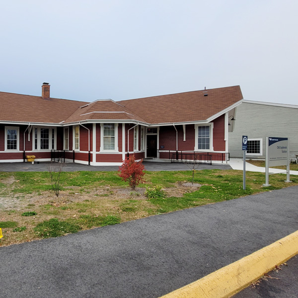
Constructed in 1873 by the New Haven Railroad, the depot's "V" layout originally accommodated passengers of two railroads who used separate platforms but shared the waiting room.
455 Boston Post Road
Old Saybrook, CT 06475-1516
- Facility Ownership: Amtrak
- Parking Lot Ownership: Amtrak
- Platform Ownership: Amtrak
- Track Ownership: Amtrak
Margaret Clark
Regional Contact
governmentaffairsnyc@amtrak.com
For information about Amtrak fares and schedules, please visit Amtrak.com or call 1-800-USA-RAIL (1-800-872-7245).
Located at the northern end of town just off Main Street, the Old Saybrook Intermodal Transport Facility is easily accessible via the Boston Post Road (US-1), the Middlesex Turnpike (State Route 154), and the Connecticut Turnpike (I-95). It is served daily by Northeast Regional trains. The Shore Line East Railroad gives commuters access to coastal towns between New Haven and New London, while the Estuary Transit District runs bus routes that serve the coast as well as the Connecticut River Valley as far north as Middletown.
To the casual observer, the design of the Old Saybrook station might seem odd, as it is laid out in a wide “V” shape; half of the building parallels the tracks of the busy Northeast Corridor (NEC) while the rest angles away from the tracks to the southeast. The floor plan itself is a clue to the station’s past, as it was served by the New York, New Haven, and Hartford Railroad—commonly known as the “New Haven”—and the Connecticut Valley Railroad, which crossed one another in Old Saybrook. Constructed in 1873 by the New Haven, the building’s two wings accommodated passengers of both railroads who used separate platforms but shared the waiting room. At the apex of the “V” facing the street, an extended three sided bay housed the ticket office. Although the New Haven’s right-of-way remains in place and is now part of the NEC, the Connecticut Valley Railroad tracks on the east side of the station have been removed.
Similar to many of its contemporaries, the one story depot sports a simple gabled roof with large eaves that sheltered passengers from inclement weather as they waited for the arrival of the train. In an elegant touch, the brackets, which support the eaves, terminate at their bottoms in tightly wound scrolls. Early travelers would have admired the fancy gingerbread trim along the edges of the roof, but it was later removed as elaborate Victorian ornamentation fell out of fashion. The wood frame depot is covered in clapboard painted a deep and rich red that contrasts strongly with all of the trim—at the base and water table, the brackets, and around the windows and doors—that is picked out in a striking, crisp white. At the attic level, the gables feature round-arched windows grouped in triplets that add some delightful curves to an otherwise rectilinear building.
Compared with historic images including photographs and postcards, the station appears little changed although its surroundings have been modified. A board and batten freight house erected concurrent with the station was moved around the property many times before it finally came to rest directly west of the depot. The freight house has a distinct New England flavor due to its saltbox design—one side of the gabled roof slopes down further than the other—that recalls the unpretentious homes built by the region’s first English colonists. Trackside, the building has large and wide sliding doors that would have made it easy to roll in carts laden with crates and parcels unloaded from the train. Raised a few feet off the ground, the doors were originally accessed via a loading dock that was at the same height as a boxcar floor. It also features a deep eave that kept items dry while they were transferred between the freight house and the train.
In the mid-1980s, the five acres that Amtrak owned around the station were redeveloped into the Saybrook Junction Marketplace. Built east of the station, the complex contained shops and offices in a setting meant to evoke the best qualities of a New England village; the freight house was converted into a restaurant space. Saybrook Junction Marketplace was one of the first instances in which Amtrak allowed a private developer to take a long term lease on one of its properties in an effort to create a more attractive and active transportation hub. During the late 1990s, the right-of-way was upgraded with concrete ties for introduction of the high-speed Acela Express service in 2000. In 2002, a new pedestrian overpass was built across the tracks and high-level platforms were installed at a total cost of $2.6 million.
Dutch navigator Adriaen Block was one of the first European explorers to carefully investigate and map the Connecticut and Rhode Island coasts in 1614. At the time, the area that is now Old Saybrook—where the Connecticut River meets Long Island Sound—was inhabited by Pequot American Indians who had only recently driven out members of the Niantic tribe. About a decade later, in an effort to foster a fur trade with local American Indian groups, the Dutch established a settlement on Saybrook Point, an easily defensible peninsula between the North and South Coves. It failed within a couple of years and was abandoned, but rivalry between the Dutch at New Amsterdam (now New York City) and the English at Plymouth led the latter to move into the Connecticut River Valley, where they in turn chose to refortify Saybrook Point in 1635.
The English asserted control over the land under the authority of the Warwick Patent, a claim since proven to be of dubious origin and legality. Robert Rich, Earl of Warwick, was a staunch Puritan who rejected many of the policies of King Charles I. In his role as president of the Council for New England, he became involved in land deals in the American colonies. In 1631, he conveyed a stretch of land from the Narragansett River to the Pacific Ocean to a group of fellow Puritans who desired to establish a colony of like-minded men, most of noble birth. The Puritans especially wished to “purify” the Church of England of any remaining Roman Catholic rituals and resented the attempts by Charles I to move the Church away from Puritan influence. It has never been established that Warwick actually owned the territory that took his name or whether he had the authority to give it away.
John Winthrop, Jr., eldest son of the first governor of the Massachusetts Bay Colony, was asked to organize the settlement of the Warwick Patent. He seemed an appropriate choice, as he had already played a part in the establishment of Ipswich, Massachusetts. “Saye-Brooke,” considered the oldest settlement on the Connecticut coast, was named after two of its English proprietors: William Fiennes, 1st Viscount Saye-and-Sele, and Robert Greville, 2nd Baron Brooke. In later years, Winthrop became active in colonial politics, and was elected governor of the Connecticut Colony in 1657; five years later he won a royal charter for the colony from King Charles II, thereby strengthening the state with specified legal powers.
Under the direction of Lieutenant Lion Gardiner, a military engineer who had been sent from England, a fort and town were laid out on Saybrook Point. The original plan dictated that the proprietors would live within a protective palisade while other settlers would reside outside of it in close proximity to their agricultural fields. Attacks from the Pequots were frequent in the early years, resulting in the destruction of vital crops and livestock. Winthrop only remained in charge for one year, and proprietor George Fenwick—the sole grantee to actually settle in Saybrook—took over in 1639. Political and social changes in England led to the outbreak of Civil War in 1642, whose end result was a Puritan-influenced Commonwealth under Oliver Cromwell. Consequently, Saybrook’s reason for being evaporated, and in 1644 Fenwick was authorized to sell the fort and surrounding lands to the Connecticut Colony concentrated upriver at Hartford. The seal of the Saybrook Colony was also included as part of the deal, and it later became the basis for the Connecticut state flag. Gardiner’s fortification was retained by the Hartford leadership as a guard against enemy attacks, and was rebuilt after fire destroyed the original structure in 1647.
Over the next two centuries, Saybrook grew slowly, but prospered as a point of trade where goods were transferred from deep draft ocean-going ships to smaller vessels that could maneuver around the shifting sandbars and wetlands at the river’s mouth. Along the northern shoreline of Saybrook Point, wharves and warehouses were constructed to store cargo until it could be distributed. Ship building also developed as an important industry, as did fishing. Plentiful stocks of shad and other fish were caught, cleaned, and salted so that they could be sold to inland communities. The Connecticut River was vital to New England trade, as it is one of the only waterways in the region that is navigable deep into the interior. Before the advent of good highways and railroads, it was the primary conduit for the movement of people and goods between the Atlantic coast and communities as far north as Vermont and New Hampshire.
In 1701, town leaders established Saybrook as an educational center with the opening of what is now Yale University, but the trustees moved it to New Haven 15 years later in an effort to attract a wider pool of students. Saybrook also became well known for the “Saybrook Platform,” a plan for the governmental organization of the colony’s Congregational churches that was observed for much of the 18th century.
Old Saybrook never developed into an industrial center, but early in the 19th century it took advantage of changes in American business to blossom into a popular, if quiet, vacation spot that saw visitors such as writer Charles Dickens. Industrialization led to the organization of business enterprises that were larger and more complex than anything known until that time. Employees might be scattered across numerous offices, but managed from a central headquarters. For rising middle class professionals, practices such as paid vacation fostered leisure time and tourism. The advent of railroads also made it possible to travel well beyond one’s home town or immediate surroundings, and Old Saybrook became accessible by rail in 1852.
An east-west route along the Connecticut coast proved a challenge to rail investors, for any trackage would have to cross numerous rivers and take into account the undulating shoreline. In 1848, the New Haven and New London Railroad (NH&NL) was chartered to build a line between its namesake cities, and it opened in the summer of 1852. That same year, the New London and Stonington Railroad was chartered to bridge a gap between the NH&NL at New London and the New York, Providence, and Boston Railroad (NYP&B) at Stonington, Connecticut on the border with Rhode Island. From Stonington, the NYP&B ran up to the major city and port of Boston. In 1857, the New London and Stonington merged with the NH&NL to form the New Haven, New London, and Stonington Railroad. The long awaited connection with the NYP&B was made in December 1858, and through service between Boston and New York began the next year via the New York and New Haven Railroad which since 1849 had linked New Haven and the east side of Manhattan. Until the completion of the railroad bridge over the Connecticut River in 1870, passenger and baggage cars were floated across the waterway via ferries between Old Lyme and Old Saybrook.
By the end of the century, all of these lines had come under the control of the New Haven, which quickly became the dominant freight and passenger line in southern New England by absorbing smaller lines in order to control the routes linking Boston and New York City. The right-of-way through central Rhode Island and along the Connecticut coast was known as the “Shore Line” to distinguish it from the main line that passed through Springfield, Massachusetts. By the 1920s, the New Haven had more than 2,000 miles in its portfolio and it was estimated that it carried 10 percent of American passenger rail traffic.
An overland trip from Old Saybrook up the river to the state capital was a tedious affair until 1871 when the Connecticut Valley Railroad (CVR) opened its 45 mile line between the two cities. At Old Saybrook, passengers could board New York City bound ferries. The line was chartered in 1868 to provide an alternative to goods movement on the river, which was often blocked in winter due to ice. The line was extended a few miles south in 1872 to Fenwick, a seaside village named after the early governor and proprietor of the Saye-Brooke Colony. From mid-century on, Fenwick became a popular destination for tourists who sought a cool respite from the summer heat of the city. Many people “summered” in the community for months and eventually constructed their own cottages which were easily accessible from the depot located at Nibang and Freeman Avenues.
Rather than work its way overland, the railroad built causeways and bridges to cross the North and South Coves. On the eastern edge of Saybrook Point—where Winthrop established the town in 1635—the CVR destroyed the remains of Fort Saybrook and reshaped the land to accommodate a roundhouse, turntable, rail yard, signal tower, storehouse, steamboat dock, and other facilities. The tomb of Lady Fenwick—wife of the proprietor—was also relocated and it became a local landmark that provided a tangible link to Old Saybrook’s origins. In 1876, the railroad went bankrupt since its endpoints were not large enough to generate substantial passenger and freight traffic.
Reorganized in 1879, it operated independently until leased by the New Haven in 1887. Subsequently, the CVR became known as the “Valley Division” of the New Haven and operated south to Fenwick until 1916 and to Saybrook Point until 1922 when automobiles became tourists’ prime means of accessing the shore. In fact, the bridge across the South Cove was converted for automobile traffic and remains in use today. Although the tracks have long since been pulled up, the right-of-way can be traced along the North Cove by following the narrow and straight bits of land that lead towards Saybrook Point. Torn down in the 1920s, the roundhouse lives on through an archaeological dig that uncovered its foundations, now a centerpiece of Fort Saybrook Monument Park. Its 18 acres offer beautiful views of the Connecticut River and surrounding wetlands that support populations of blue herons, snowy white egrets, ospreys, and other birds and animals. Throughout the park, interpretive plaques explore the history of the site, including its evolving plant and animal life and periods as a fort, early settlement, and railroad center.
Station Building (with waiting room)
Features
- ATM not available
- Elevator
- Payphones
- No Quik-Trak kiosks
- Restrooms
- Ticket sales office
- Unaccompanied child travel allowed
- Vending machines
- No WiFi
- Arrive at least 45 minutes prior to departure if you're checking baggage or need ticketing/passenger assistance
- Arrive at least 30 minutes prior to departure if you're not checking baggage or don't need assistance
Baggage
- Amtrak Express shipping not available
- No checked baggage service
- No checked baggage storage
- Bike boxes not available
- No baggage carts
- Ski bags not available
- No bag storage
- Shipping boxes not available
- Baggage assistance provided by Station Staff
Parking
- Same-day parking is available; fees may apply
- Overnight parking is available; fees may apply
Accessibility
- Payphones
- Accessible platform
- Accessible restrooms
- Accessible ticket office
- Accessible waiting room
- Accessible water fountain
- Same-day, accessible parking is available; fees may apply
- Overnight, accessible parking is available; fees may apply
- High platform
- Wheelchair available
- No wheelchair lift
Hours
Station Waiting Room Hours
| Mon | 06:00 am - 10:00 pm |
| Tue | 06:00 am - 10:00 pm |
| Wed | 06:00 am - 10:00 pm |
| Thu | 06:00 am - 10:00 pm |
| Fri | 06:00 am - 10:00 pm |
| Sat | 06:00 am - 10:00 pm |
| Sun | 06:00 am - 10:00 pm |
Ticket Office Hours
| Mon | 06:00 am - 10:00 pm |
| Tue | 06:00 am - 10:00 pm |
| Wed | 06:00 am - 10:00 pm |
| Thu | 06:00 am - 10:00 pm |
| Fri | 06:00 am - 10:00 pm |
| Sat | 06:00 am - 10:00 pm |
| Sun | 06:00 am - 10:00 pm |
Passenger Assistance Hours
| Mon | 06:00 am - 10:00 pm |
| Tue | 06:00 am - 10:00 pm |
| Wed | 06:00 am - 10:00 pm |
| Thu | 06:00 am - 10:00 pm |
| Fri | 06:00 am - 10:00 pm |
| Sat | 06:00 am - 10:00 pm |
| Sun | 06:00 am - 10:00 pm |
Checked Baggage Service
Parking Hours
Quik-Track Kiosk Hours
| Mon | 06:00 am - 10:00 pm |
| Tue | 06:00 am - 10:00 pm |
| Wed | 06:00 am - 10:00 pm |
| Thu | 06:00 am - 10:00 pm |
| Fri | 06:00 am - 10:00 pm |
| Sat | 06:00 am - 10:00 pm |
| Sun | 06:00 am - 10:00 pm |