
Oakland, CA - Coliseum/Airport Station (OAC)
Opened in 2005, the station is adjacent to Oakland’s major sports and entertainment complex, and it also offers an easy connection to Oakland International Airport.
Coliseum/Airport Station
700 73rd Avenue
Oakland, CA 94621-3316
Annual Station Ridership (FY 2024): 30,163
- Facility Ownership: City of Oakland
- Parking Lot Ownership: City of Oakland
- Platform Ownership: City of Oakland, Union Pacific Railroad
- Track Ownership: Union Pacific Railroad
Alex Khalfin
Regional Contact
governmentaffairsoak@amtrak.com
For information about Amtrak fares and schedules, please visit Amtrak.com or call 1-800-USA-RAIL (1-800-872-7245).
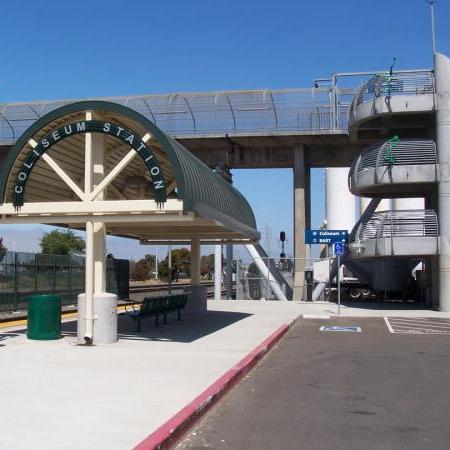
The Oakland-Coliseum station consists of a concrete platform accented with three shelters to protect travelers from inclement weather. It is adjacent to Oakland’s major sports and entertainment complex, which includes the coliseum and the Oakland Arena. These structures are located in the Coliseum Redevelopment Area southeast of downtown and the principal harbor area. Established in 1995, the 11 square mile tract of land—primarily consisting of industrial and commercial uses—has been targeted for strategic reinvestment.
One of the initial goals of the redevelopment plan was to establish a new station on the Capitol Corridor in East Oakland to better serve residential neighborhoods, patrons of the stadium and arena, and travelers wishing to access nearby Oakland International Airport. In the late 1980s, the state of California decided to make significant investments in intercity passenger rail. With a service area that spans eight northern counties, the Capitol Corridor was inaugurated in 1991 and envisioned as an alternative to congested Interstate 80/880. The location of the new Amtrak station was also determined by its proximity to an existing stop on the Bay Area Rapid Transit (BART) system that serves the greater Bay Area.
Announced in fall 2002, the station was completed three years later and welcomed the first passengers on June 6, 2005. The approximately $6 million facility was funded through contributions from the Oakland Redevelopment Agency, Caltrans, the Capitol Corridor Joint Powers Authority, and the Alameda County Congestion Management Agency.
While the Amtrak and BART stations do not share a common building or platform, they are within walking distance of one another and are linked by a pedestrian bridge that also provides access to the coliseum and arena. From the BART station, passengers can hop aboard the BART to OAK, a train-to-plane service that operates to Oakland International Airport. Automated people movers operate when BART is open, avoiding all traffic. The ride takes eight minutes and service is frequent throughout the day.
In June 2024, Amtrak celebrated completion of a $2.5 million upgrade project at the Oakland-Coliseum station to provide customers with a more accessible and comfortable experience. Working with the city of Oakland, Amtrak advanced a series of accessibility improvements in accordance with the Americans with Disabilities Act (ADA). Updates included a resurfaced platform with tactile warning surfaces along the platform edge so passengers with vision disabilities can safely navigate the area. New signage and pedestrian pathways also provide better access to the surrounding community. Due largely to Congressional investments, the improvements are part of Amtrak’s commitment to creating safer, accessible facilities across its national network through its ADA Stations Program.
When Spanish explorers first passed through the Bay Area in the 1770s, they encountered small villages inhabited by Ohlone American Indians who moved between the uplands and the shore where they hunted amid the wetlands and gathered grasses to construct shelters. In the latter half of the 18th century, the Spanish Empire based in Mexico began to make greater efforts to secure the California coast. Franciscan missionaries worked toward the conversion of the region’s American Indians to Christianity, a stated goal of Spanish colonization.
In addition to providing land to support the missions and forts, the royal Spanish government also presented tracts to those viewed as loyal servants of the empire. In 1820, just a year before Spain would lose most of its North American possessions to a newly-formed Mexico, the royal governor granted approximately 45,000 acres on the east side of San Francisco Bay to Luis María Peralta. Although he had served in the Spanish Armed Forces for more than 40 years and was also the Royal Commissioner of nearby San Jose, Peralta’s grant was considered unusually large. Comparing it to the present-day map of the area, the parcel stretched along the shore of San Francisco Bay from Albany in the north to San Leandro in the south, and therefore encompassed most of Oakland.
Peralta never lived on the land, which he called Rancho San Antonio; instead, it was settled and managed by his four sons, each of whom built a home on the property. Under Mexican rule, trade restrictions were lifted and the Peralta family prospered. More than 8,000 cattle and 2,000 horses grazed on the land and products such as hides and tallow were sought after by American merchants from the east. To facilitate the shipping of ranch goods, the Peraltas built a wharf in the vicinity of present day 14th Avenue where it meets the Brooklyn Basin. During the 1840s, the family also approved of the clear cutting of stands of ancient redwoods in the Oakland Hills for lumber, a process that intensified with the onset of the Gold Rush in 1848. The family’s principal hacienda, consisting of a large adobe structure and other outbuildings, became a well-known stopping point for travelers. In 1842, Luis Maria formally divided the estate among his children; the Oakland Coliseum Amtrak station sits on the 9,400 acre parcel given to his son Ignacio.
Change was the byword of mid-19th century California, for within a generation, the land passed from Spain to Mexico and finally to the United States following the Mexican-American War and the 1848 Treaty of Guadalupe Hidalgo. The United States promised to honor the Spanish and Mexican land grants, but in order to prove title to the land, owners such as the Peraltas often had to undergo lengthy and expensive court cases.
Word that gold had been discovered at Sutter’s Mill in the Sierra Nevada Mountains spread like wildfire, setting off what is considered the greatest voluntary mass migration of people in human history. Hundreds of thousands of Americans and foreigners set their sights on the perceived riches of California and quickly swelled the territory’s population. While only a lucky few actually found gold, many discouraged miners determined that the fertile lands of the region were themselves a prize. Unfortunately for the Peraltas, people squatted on their land, unaware that it was privately owned. One of those illegal settlers was Horace Carpentier, who in 1850 laid out a town and began selling lots along San Antonio Creek (now the Inner Harbor). Convincing the state to incorporate the small town, Carpentier gained exclusive rights to waterfront development which included the construction of wharves and piers. As the creek was dredged so that it could serve as a harbor, the silt and other material was dumped onto the bordering marshes to create solid land and therefore a new shoreline.
In 1868, Carpentier sold his stake in the waterfront to the young Central Pacific Railroad (CP), which planned on making the city the western terminus of the nation’s first transcontinental railroad. It proceeded to construct the Long Wharf at Oakland Point. At West Oakland, the railroad established one of its largest rail yards and servicing facilities; it continued operations under the successor Southern Pacific Railroad.
The city quickly grew into a major West Coast port, and its population jumped to approximately 35,000 by 1880. In the meantime, the Peraltas finally triumphed in court and gained full title to their land, but the legal fees, fights with squatters, and internal family struggles resulted in the dissolution of the rancho by the close of the century. Visitors to Oakland may stop by Peralta Hacienda Historical Park to learn more about the family and the early development of the East Bay area. After the great Hayward Earthquake of 1868 destroyed the family adobe, Antonio Maria Peralta erected a new wood frame home nearby, and today it forms the core of the park. The footprints of the adobes constructed in 1820 and 1840, as well as the wall that surrounded the property, are still visible. With its playground, gardens, and historical exhibits, this city-owned park keeps alive the welcoming hospitality for which the Peraltas were long noted.
In Oakland’s early years, shipping and commercial activity was concentrated in San Antonio Creek between Oakland and Alameda. To the south, around San Leandro Bay, development was less intensive and the brackish body of water was known for large expanses of nutrient-rich wetlands that supported migratory populations of birds, as well as fish and other animals. With a sense of awe, early visitors described the great populations of ducks, geese, quail, and other fowl living in the area, and the marshes around San Leandro Bay became a prime hunting ground. The waters of the bay were also fertile ground for commercial oyster farming; writer Jack London would chronicle the exploits of “oyster pirates” who raided the beds of bivalves. For a brief period during the Gold Rush years, the bay also served as a commercial harbor after wharves and small warehouses were constructed along Damon Slough. On the west side of the bay, residential neighborhoods sprouted on the edge of the Alameda, which at the time was still a peninsula that divided San Leandro Bay from San Antonio Creek.
As Oakland’s population grew and the footprint of the city expanded, a plan was put forth by the federal government in the 1870s to enhance the port to better accommodate large ships with deep drafts. Most of the improvements were concentrated on San Antonio Creek, but the overall plan also included changes to San Leandro Bay. Engineers believed that by digging a canal between the two bodies, the water from the bay could be used to flush silt out of the harbor, thereby keeping it clear for shipping. The scheme was not completed until 1902, never worked as planned, and led to the erosion of the beachfront along the Alameda peninsula which in effect became an island. In the process, wetlands were destroyed and filled to create new parcels for industrial use.
Other projects also contributed to the destruction of the San Leandro marshes, including a trestle constructed across the bay by the narrow gage South Pacific Coast Railroad. Laid down in the 1870s to link Alameda and Santa Cruz, the railroad passed through Santa Clara and adjacent farmlands and provided access to stands of timber in the Santa Cruz Mountains. The line was later subsumed into the Southern Pacific Railroad—which also controlled the CP—and the tracks through the marsh were rerouted to the east of San Leandro Bay.
Industries such as metals, canning, automobiles, and shipbuilding drove Oakland’s economy during the first half of the 20th century. In 1927, the Port of Oakland was created to manage waterfront operations and oversee improvements to the port that would encourage economic growth. That same year, the Port Commission was given jurisdiction over Oakland’s new airport, whose runway was completed in September. A year earlier, the city had spent more than a half million dollars to purchase 600 acres on Bay Farm Island bordering San Leandro Bay on the south. Flat and far from heavily populated residential areas, yet still close to the city, the site was ideal for an airport. Under the Commission’s control, an additional 225 acres were added to the complex and a channel was dredged through the bay to provide water access to the site.
Dedicated by Charles Lindbergh, who earlier that year had set a record as the first individual to cross the North Atlantic Ocean by plane, the Oakland Municipal Airport was considered one of the most modern when it opened for service. In December 1927, Boeing Air Transport began transcontinental passenger and airmail service to New York City. Within a couple of years, hangars, a passenger terminal, and a restaurant were added to the site, and in 1930 it boasted the world’s first airport hotel. Those initial years were filled with daring exploits of which history is written. It was an age when aviation was fresh and exciting, and new technologies were developing rapidly.
Aviators such as Amelia Earhart, Eddie Rickenbacker, and Howard Hughes seemingly broke flight and time records every few months. In 1928, Sir Charles Kingsford-Smith departed Oakland for his home country of Australia via Hawaii and Fiji. Aboard their Fokker Southern Cross, he and his crew successfully completed the first flight between North America and Australia in only seven days. Earhart made many appearances at the airport and first generated headlines in 1931 when she landed in Oakland after the first transcontinental autogiro flight. Four years later, she was the first person to fly solo from Hawaii to California, again landing in Oakland. Her famed round-the-world trip with navigator Fred Noonan began at the airport in May 1937, only to end in mystery and presumed tragedy.
During World War II, all passenger services shifted to San Francisco while Oakland airport was requisitioned for the war effort. All U.S. fighters, bombers, and transport planes headed for the Pacific Theater went through Oakland, and a new runway opened in 1945. In the 1960s, the airport entered the modern age of jet plane travel, which also brought an expansion into the wetlands around Bay Farm Island. At the start of the 21st century, Oakland International Airport serves more than 14 million passengers a year and employs approximately 8,000 people. About one-third of that workforce deals with the more than 700,000 tons of cargo that annually move through the facility.
In the 1960s, city leaders decided to construct a $25 million stadium-arena facility on the east side of San Leandro Bay that would be accessible via the newly completed Nimitz Freeway. Built on 120 acres of marshland, the Oakland-Alameda County Coliseum Complex included two buildings. Each has a unique design in that the playing fields are sunken below ground level, therefore allowing spectators to enter at mid-level. Envisioned as an all-in-one facility, the 55,000 seat Oakland Coliseum was designed to host football and baseball games, although the city only possessed a major league football team—the Raiders.
Part of the impetus for the stadium’s construction came from the desire to lure other teams to Oakland, a plan which paid off a couple of years later when the Kansas City Athletics took up residence in the stadium and the Warriors basketball team moved into the arena. The first game held in the coliseum was played in September 1966 when the Raiders took on the Kansas City Chiefs, and Governor Ronald Reagan threw out the first pitch to open the baseball season on April 17, 1968. Original plans show that the complex was meant to accommodate auto racing around its perimeter, but this scheme was never carried out. Although known by various names over the years, for true Oakland fans the buildings will always be regarded as the “coliseum” and the “arena.”
The rise of the environmental movement in the 1970s began to change attitudes towards natural resources, and in the San Francisco Bay Area, this meant that great attention was give to the fate of the marshes that had once lined the shores. Long considered disposable and therefore destroyed by dredging and filling, marshes became better understood for the roles that they play as natural water filters and as important habitats for migratory birds and other animals. Near the Oakland Coliseum Amtrak station, San Leandro Bay lost nearly 90 percent of its wetlands, which shrank from more than 2,000 acres in 1915 to a mere 70 by 1972. Since then, efforts have been undertaken to bring the marshes back to life and put them in the public eye.
Along the Oakland side of the bay, visitors to the 741 acre Martin Luther King, Jr. Regional Shoreline may picnic, hike, fish, and bike near the restored wetlands. One of the most popular areas of the park is the Arrowhead Marsh, which is a destination for avid and amateur birdwatchers alike. Always alive with the sweet songs of its avian inhabitants, the wetlands host a full symphony during the spring and fall when flocks stop in the bay as part of their journeys along the Pacific Flyway. With patience, bird enthusiasts might spy marbled godwits, horned and eared grebe, buffleheads, golden-crowned sparrows, and snowy egrets among many others. The most prized sighting is the California clapper rail, an endangered species found mainly in the marshlands around San Francisco Bay. Its most prominent features are a long, downward curving bill and a breast of cinnamon colored feathers. During the nesting season in late spring, clapper rails can be seen in Arrow Marsh collecting Pacific cordgrass and pickleweed to construct canopies over their nests.
The Capitol Corridor route is primarily financed and operated in partnership with the State of California. It is managed by the Capitol Corridor Joint Powers Authority (CCJPA), which partners with Amtrak, the Union Pacific Railroad, Caltrans and the communities comprising the CCJPA to continue development of a cost-effective, viable and safe intercity passenger rail service.
Platform with Shelter
Features
- ATM not available
- No elevator
- Payphones
- No Quik-Trak kiosks
- No Restrooms
- Unaccompanied child travel not allowed
- No vending machines
- No WiFi
- Arrive at least 30 minutes prior to departure
Baggage
- Amtrak Express shipping not available
- No checked baggage service
- No checked baggage storage
- Bike boxes not available
- No baggage carts
- Ski bags not available
- No bag storage
- Shipping boxes not available
- No baggage assistance
Parking
- Same-day parking is available; fees may apply
- Overnight parking is available; fees may apply
Accessibility
- Payphones
- Accessible platform
- No accessible restrooms
- No accessible ticket office
- No accessible waiting room
- No accessible water fountain
- Same-day, accessible parking is available; fees may apply
- Overnight, accessible parking is available; fees may apply
- No high platform
- No wheelchair
- Wheelchair lift available
Hours