
Turlock-Denair, CA (TRK)
Denair takes its name from a Santa Fe Railway employee who owned land in the area; along with neighboring Turlock, it prospered as an agricultural community in the 20th century.
- Facility Ownership: BNSF Railway, Amtrak
- Parking Lot Ownership: BNSF Railway
- Platform Ownership: BNSF Railway
- Track Ownership: BNSF Railway
Alex Khalfin
Regional Contact
governmentaffairsoak@amtrak.com
For information about Amtrak fares and schedules, please visit Amtrak.com or call 1-800-USA-RAIL (1-800-872-7245).
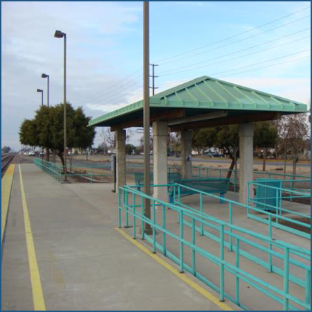
The Turlock-Denair station consists of a concrete platform with a modest open air shelter and benches. Four corner columns support a green, hipped, seamed-metal roof that protects passengers from inclement weather while they await the arrival of the train. Surrounding the pavilion are landscaped beds planted with colorful flowering trees and bushes.
The station serves two communities originally supported by rival railroads. Turlock was established by the Southern Pacific Railroad (SP) as it built through the area in the early 1870s. A few decades later, the Atchison, Topeka, and Santa Fe Railroad (ATSF) constructed a line roughly three miles east of the SP, and the town of Denair developed along the tracks. When the Amtrak San Joaquins service was established in 1974, the ATSF line was chosen for the route and therefore Denair gained the station.
On November 3, 2025, the Amtrak San Joaquins was rebranded to Gold Runner. Introduced by the San Joaquin Joint Powers Authority, which is responsible for the management and administration of the service, the name unites rail and Thruway bus service under a single, cohesive identity. The Gold Runner name reflects both the heritage and momentum of the Central Valley, representing speed, connection and California pride.
Turlock and Denair are located at the northern end of the San Joaquin Valley. In the late 18th and early 19th centuries, the region was explored by Spaniards from the coast such as Gabriel Moraga. Early travelers encountered bands of the Yokut American Indians, and the valley was not settled by European-Americans until the 1820s. After Mexico gained independence from Spain in 1821, much of the land in southern and central California was broken up into large estates that were often doled out to the friends of those in power. Although isolated from populated coastal areas due to the mountain ranges, the valley was used for grazing. The Gold Rush of 1849 attracted adventures to California from the eastern and Midwestern United States. Many dreams of gold came to naught but settlers remained in the west and built lives. Subsequently, many of the Yokut were driven off their land and onto designated reservations.
One of those gold seekers was John William Mitchell, who had traveled in 1851 from Connecticut to San Francisco via Cape Horn. Working hard in the frenetic gold-rush environment, he became rich not from the mining of the precious metal, but rather through carpentry. With thousands of new arrivals in the area, his building services were in high demand. Mitchell wisely invested his wages in other ventures, particularly land speculation in the San Joaquin Valley. Once gold fever subsided, Mitchell used herds of sheep to graze and clear his land, which he then planted with wheat. Within decades of his arrival, Mitchell owned more than 100,000 acres and became a dominant figure in the local wheat market.
The primary way to ship the grain to growing coastal markets was to float it down the Tuolumne River or to take it overland to Stockton. Mitchell therefore established a river landing on the Tuolumne in 1867. Recognizing the agricultural potential of the valley but the difficulty of existing water and land routes, various railroads contemplated a route into the interior. By the early 1870s, the SP—and the Central Pacific Railroad (CP), which it controlled—began construction on a line that would run down the valley to ultimately connect San Francisco and Los Angeles. Those cities were California’s two most important ports and political and economic centers for the northern and southern regions of the state, respectively.
As the CP laid track to the southeast, it approached Mitchell with a request to pass through his river town, but he refused. Rebuffed, the railroad took an alternate path and Mitchell’s settlement soon died as the villagers moved to newly established railroad towns such as Modesto. Witnessing the power that the tracks could exert on the form of the landscape, Mitchell soon went back to the CP and offered some of his land for a depot, as well as cash to build the line.
The railroad wanted to name the town in Mitchell’s honor, but he declined. Although various theories have been put forth concerning the name “Turlock,” recent scholarship seems to indicate that it was chosen by early resident H.W. Lander. Seeing the Gaelic word “turlough” in a magazine, Lander thought it was pretty and suggested it to the local post master. Meaning “a lake that dries up in summer,” it soon morphed into “Turlock.”
Founded in 1871, Turlock was a typical railroad town in that its principle streets were laid out parallel to the tracks. By that fall, the CP had erected a one story combination depot that accommodated passenger and freight functions. Photographs taken 30 years later show that it was a simple rectangular structure with a gabled roof; deep eaves supported by brackets protected passengers as they waited outside for the train. Trackside, a projecting rectangular bay with windows on all three sides allowed the station master an unobstructed view down the tracks in order to monitor traffic on the line. One end was devoted to freight storage, as indicated by the raised platform that facilitated the easy movement of parcels and crates between the boxcars and the storage area. A telegraph office and a switching yard were also located nearby.
Turlock quickly became a shipping point for regional farmers, most of whom grew wheat. The town prospered for two decades until it’s financial and transportation dominance over the surrounding agricultural region was loosened by the construction of SP branch lines to the east and west. In 1893, a fire spread through downtown and destroyed many blocks.
In the last quarter of the 19th century, the SP’s monopoly on rapid transportation led to complaints from farmers and travelers about high freight and passenger rates. The primary rival to the SP in California was the ATSF, which had entered the far southern area of the state in the 1880s. In the mid-1890s, the new San Francisco and San Joaquin Valley Railroad (SF&SJV) proposed an alternate route through the San Joaquin Valley; by purchasing the SF&SJV in 1899 and securing trackage rights over the SP’s Tehachapi line, the ATSF gained a route between Los Angeles and the San Francisco bay area.
Wheat had been a profitable crop for Turlock farmers, but good years were periodically followed by droughts that ruined hard-built livelihoods. Coupled with competition from towns along the new rail lines, these forces threatened Turlock’s future growth. But as in much of the valley, the promise of water offered rebirth. Turlock became one of a handful of communities located in one of the state’s first irrigation districts. Irrigation offered a consistent, year-round water supply and allowed for a diversification of crops to include melons, sweet potatoes, and fruits such as peaches, apricots, and plums. The renewed prospects for the land encouraged a new wave of settlement that included transplants from the Midwest as well as newly arrived immigrants from Sweden, Portugal, Greece, and the Ottoman Empire. Trainloads of potential land buyers would step off the train at Turlock where Mitchell encouraged their agricultural dreams with images of lush fields made possible through irrigation.
Renewed growth convinced the SP to construct a larger depot at Turlock in 1915. Whereas the first station had been constructed of wood—easy to assemble and disassemble as necessary—the second station exuded permanence through the use of brick. In keeping with many California depots built in the early 20th century, it had a covered, open-air waiting room at one end. The one story structure featured a gabled roof with a large cross gable whose trackside face was decorated with stickwork typical of the then-popular Queen Anne style. Following in the footsteps of its predecessor, the building showed off its deep, bracketed eaves and a canted bay window. The original depot was moved across the tracks and used as a freight house. The second station was in operation until 1971 when the SP ended passenger service; it was later remodeled into a commercial space and still stands adjacent to Central Park.
The area known as Denair had been settled prior to the arrival of the ATSF tracks, and it was referred to as the Elmwood Colony. John Denair, an ATSF division superintendent, got wind of the railroad’s plans to establish a roundhouse and shops at Elmwood. He quietly bought up most of the land. When the company approached him to purchase the property, Denair rejected the offer and held out for more. Eventually, the ATSF gave up and established the shops to the north at Riverbank. Denair laid out a town along the tracks in 1907; located within the Turlock irrigation district, it attracted settlers and later took the founder’s name. A handful of packing plants were erected along the tracks in order to process locally grown melons and fruits.
Agriculture has remained important to Turlock and Denair for more than a century. In 1911, Turlock held the first Melon Festival to promote the riches of its land. Although it only lasted a few years, the festival later inspired the Stanislaus County Fair which is still held in Turlock each summer. During World War II, the fair was cancelled but the fairgrounds were used as a Relocation Center for Japanese-Americans. In 1942, more than 3,500 innocent citizens were forcibly relocated there from the West Coast due to unfounded fears about their loyalty to the United States. In 2010, a memorial was dedicated at the fairgrounds in honor of the internees.
This history and more can be explored at the Turlock Historical Museum located one block northeast of the old SP depot. The institution is located in a former grocery store constructed in 1910. Restored in 1999, it is one of many historic buildings in downtown that have been preserved through the efforts of local citizens and city leaders. Events held throughout the year keep the streets active.
The Gold Runner service is primarily financed through funds made available by the State of California, Department of Transportation, and is managed by the San Joaquin Joint Powers Authority.
Platform with Shelter
Features
- ATM not available
- No elevator
- No payphones
- No Quik-Trak kiosks
- No Restrooms
- Unaccompanied child travel not allowed
- No vending machines
- No WiFi
- Arrive at least 30 minutes prior to departure
Baggage
- Amtrak Express shipping not available
- No checked baggage service
- No checked baggage storage
- Bike boxes not available
- No baggage carts
- Ski bags not available
- No bag storage
- Shipping boxes not available
- No baggage assistance
Parking
- Same-day parking is available; fees may apply
- Overnight parking is available; fees may apply
Accessibility
- No payphones
- Accessible platform
- No accessible restrooms
- No accessible ticket office
- No accessible waiting room
- No accessible water fountain
- Same-day, accessible parking is available; fees may apply
- Overnight, accessible parking is available; fees may apply
- No high platform
- No wheelchair
- Wheelchair lift available
Hours
Station Waiting Room Hours
Ticket Office Hours
Passenger Assistance Hours
Checked Baggage Service
Parking Hours
| Mon | 12:01 am - 11:59 pm |
| Tue | 12:01 am - 11:59 pm |
| Wed | 12:01 am - 11:59 pm |
| Thu | 12:01 am - 11:59 pm |
| Fri | 12:01 am - 11:59 pm |
| Sat | 12:01 am - 11:59 pm |
| Sun | 12:01 am - 11:59 pm |
Quik-Track Kiosk Hours
| Mon | 24 HOURS |
| Tue | 24 HOURS |
| Wed | 24 HOURS |
| Thu | 24 HOURS |
| Fri | 24 HOURS |
| Sat | 24 HOURS |
| Sun | 24 HOURS |