
Corcoran, CA (COC)
Located on the eastern edge of town, the Corcoran depot is known for a bas-relief depicting the importance of water to the residents, agriculture and wildlife of the San Joaquin Valley.
- Facility Ownership: City of Corcoran
- Parking Lot Ownership: City of Corcoran
- Platform Ownership: BNSF Railway
- Track Ownership: BNSF Railway
Alex Khalfin
Regional Contact
governmentaffairsoak@amtrak.com
For information about Amtrak fares and schedules, please visit Amtrak.com or call 1-800-USA-RAIL (1-800-872-7245).
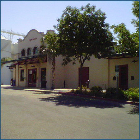
The Amtrak stop in Corcoran is located on the eastern edge of town where Whitley Avenue crosses the railroad tracks. In October 1999, the Corcoran Transit Center opened to provide a waiting room for local bus and rail passengers as well as administrative offices for the bus service. It replaced an earlier depot constructed by the Atchison, Topeka, and Santa Fe Railroad (ATSF) in 1907. Similar to its predecessor, the transit center was designed in a Spanish Revival style that makes great use of remates, or decorative curvilinear gables that add a dramatic sense of movement to the facades. In accordance with the Spanish Revival aesthetic, wall surfaces are covered in cream colored stucco; accents such as the coping of the remates and the belt course of the pavilion are highlighted in a contrasting light brown color.
The building consists of a central two story pavilion from which recessed one story wings extend to the east and west. At the second level, the pavilion sports graceful arched windows that allow abundant light into the interior. The east wing features canopies that protect passengers from inclement weather as they wait on the platform for the arrival of the train. Acknowledging Corcoran’s railroad heritage, the designers used the trackside remate to display a version of the cross-within-a-circle logo used by the ATSF. A row of trees and wooden benches line the platform and provide outdoor seating areas that are popular when the days are pleasant. On the south façade of the pavilion is a large bas-relief executed in clay. Titled “Life of the Valley,” it depicts the importance of water to the residents, agriculture, and wildlife of the San Joaquin Valley, and was completed by artist Garrett Masterson with the help of his students at the nearby Corcoran State Prison.
Corcoran is located toward the southern end of the San Joaquin Valley in the vicinity of the former Tulare Lake. Spanish explorers traveled through the region in the late 18th century and encountered the Tachi Yokut American Indians who inhabited the lands around the sizeable body of water. The Yokut population was spread throughout the valley, and “tachi” was derived from the word for “mud hen,” a duck native to the area’s wetlands.
The valley was not settled by European-Americans until the 1820s. After Mexico gained independence from Spain in 1821, much of the land in southern California was broken up into large estates that were often doled out to friends of those in power. Although isolated from populated coastal areas due to the mountain ranges, the San Joaquin Valley was used for grazing. The Gold Rush of 1849 attracted adventurers to California from the eastern and Midwestern United States. Many dreams of gold came to naught but the settlers remained in the west and built lives. Subsequently, many of the Yokut were driven off their land and onto designated reservations.
Early pioneers were attracted to the area because of the fresh water supplied by Tulare Lake. Fed by glacial snows that melted and traveled down from the Sierra Nevada Mountains, the size of the lake could vary over time depending on snow and rainfall. In the mid-19th century, the lake covered roughly 570 square miles, stretching almost 22 miles from north to south. In fact, it was considered the largest body of freshwater in the western United States. As pioneers began entering the valley and establishing farms, a system of irrigation canals and ditches was created that siphoned water from the lake to the fields. Due to irrigation and drought, by 1891 Tulare Lake had shrunk to half its earlier surface area, and within a few decades it would all but disappear. Once exposed, the lakebed was highly valued by farmers because the rivers and streams that had fed the body of water deposited rich silts that yielded astounding harvests.
Substantial population growth in the San Joaquin Valley did not occur until the arrival of the Southern Pacific (SP) and the ATSF Railroads in the late 19th century. By the early 1870s, the SP—and the Central Pacific Railroad, which it controlled—were working on a line that would run down the San Joaquin Valley to connect San Francisco and Los Angeles. Those cities were California’s two most important ports and political and economic centers for the northern and southern regions of the state, respectively. For two decades, the SP held a monopoly on rapid transportation within the region, bringing complaints from farmers who had to pay what they considered to be high freight rates.
The ATSF had entered southern California in the 1880s and presented itself as the SP’s main rival. In the mid-1890s, the new San Francisco and San Joaquin Valley Railroad (SF&SJV) proposed an alternate route through the valley; by purchasing the SF&SJV in 1899 and securing trackage rights over the SP’s Tehachapi line, the ATSF gained a route between Los Angeles and the San Francisco bay area. The main line tracks were laid through the Corcoran area in 1898; a branch line was later driven northeast to reach Visalia via Tulare.
In 1906, the Los Angeles-based Security Land and Loan Company purchased 40,000 acres of land—some of it underwater—along the ATSF right-of-way and platted a town near the settlement of “Corcoran Junction.” The head of the real estate company was H.J. Whitley, a developer who had earlier established an enclave outside of downtown Los Angeles which he called “Hollywood.” Over his long career, Whitley founded numerous towns in the greater Los Angeles area and the lower San Joaquin Valley. He had visited Corcoran Junction a year before he purchased the land, and all that stood in the vicinity of the railroad was a blacksmith shop, store, and a few homes. Agriculture had already begun and the farmers mainly produced potatoes, asparagus, and sugar beets.
Whitley proposed to call the town “Otis” after a friend, but the name did not hold. Locals continued to refer to the area as “Corcoran,” but the origin of that term remains a bit of a mystery. It is unclear whether it was named after General Corcoran, a pioneer in the valley, or Thomas Corcoran, a railroad superintendent who worked for the ATSF. Early residents labored to drain the waters of Tulare Lake in order to prepare the land for agriculture. With an elaborate system of dikes and levees in place, fields were planted with alfalfa, sugar beets, and cotton; a sugar beet factory was constructed in 1907 to process the annual crop into sugar.
The SF&SJV had erected a wood frame depot at Corcoran, but it was replaced in 1907 by a $15,000 ATSF structure that was larger and better able to facilitate the shipment of agricultural goods. Similar to many of its stations in the Southwest and California, the ATSF designed a two story building composed of reinforced concrete. This was a relatively new construction method in the early 20th century; the material was not only strong and durable, but it also helped produce a cool interior which was necessary for the hot valley summers. Aesthetically, the concrete resembled the adobe used by early Spanish settlers and therefore echoed a somewhat romanticized and adventure-filled Spanish past.
The structure was capped with graceful remates and a canopy circled the building between the first and second floors to provide shade for travelers as they waited for the train. Trackside, a projecting rectangular bay featured windows on all three sides and allowed the station master an unobstructed view down the tracks in order to monitor traffic on the line. A one-story freight building was attached to one end of the depot, and was identified by the wide doorways and the small, high windows that provided security for the goods kept inside. A ramp led up to the freight building’s loading dock which was built to the height of the boxcar doors; this design allowed for the easy transfer of crates and parcels between the train and the freight room. At the junction of the main line and the branch line to Visalia, Corcoran became a busy shipping point and railroad offices were located on the second floor of the depot.
A century later, Corcoran remains an important agricultural community in one of the most productive farming regions of North America. A truly diverse array of crops dots the fields, ranging from wheat to nuts and cotton. Since the mid-20th century, dairies have contributed greatly to the local economy, and creameries and cheese plants have been built to process the milk.
One of the largest enterprises in the area is the J.G. Boswell Company which owns about 150,000 acres around Corcoran. Founded in 1925 by a cotton broker who headed to California after a boll weevil infestation destroyed his business in Georgia, the family owned farming operation grew to encompass tens of thousands of acres and is considered one of the first large-scale agribusinesses in the country. The lands still produce numerous crops with a concentration on high quality pima cotton and tomatoes. Research at the farm has led to the creation of new, more productive seeds used across the nation.
Corcoran’s small town roots and agricultural past are put on display every fall during the Cotton Festival and Parade which coincide with the start of the cotton harvest. Events include a pancake breakfast, music, craft show, frog-jumping contest, puppet shows, and dancing in the streets. The most popular events are the parade with floats sponsored by local businesses, and the crowning of the King and Queen of the Cotton Festival.
The Gold Runner service is primarily financed through funds made available by the State of California, Department of Transportation, and is managed by the San Joaquin Joint Powers Authority.
Station Building (with waiting room)
Features
- ATM not available
- No elevator
- Payphones
- Quik-Trak kiosks
- Restrooms
- Unaccompanied child travel not allowed
- No vending machines
- No WiFi
- Arrive at least 30 minutes prior to departure
Baggage
- Amtrak Express shipping not available
- No checked baggage service
- No checked baggage storage
- Bike boxes not available
- No baggage carts
- Ski bags not available
- No bag storage
- Shipping boxes not available
- No baggage assistance
Parking
- Same-day parking is available; fees may apply
- Overnight parking is available; fees may apply
Accessibility
- Payphones
- Accessible platform
- No accessible restrooms
- No accessible ticket office
- No accessible waiting room
- No accessible water fountain
- Same-day, accessible parking is available; fees may apply
- Overnight, accessible parking is available; fees may apply
- No high platform
- No wheelchair
- Wheelchair lift available
Hours
Station Waiting Room Hours
| Mon | 08:00 am - 12:00 pm 01:00 pm - 05:00 pm |
| Tue | 08:00 am - 12:00 pm 01:00 pm - 05:00 pm |
| Wed | 08:00 am - 12:00 pm 01:00 pm - 05:00 pm |
| Thu | 08:00 am - 12:00 pm 01:00 pm - 05:00 pm |
| Fri | 08:00 am - 12:00 pm 01:00 pm - 05:00 pm |
| Sat | CLOSED |
| Sun | CLOSED |
Ticket Office Hours
Passenger Assistance Hours
Checked Baggage Service
Parking Hours
Quik-Track Kiosk Hours
| Mon | 08:00 am - 05:00 pm |
| Tue | 08:00 am - 05:00 pm |
| Wed | 08:00 am - 05:00 pm |
| Thu | 08:00 am - 05:00 pm |
| Fri | 08:00 am - 05:00 pm |
| Sat | CLOSED |
| Sun | CLOSED |