
Carpinteria, CA (CPN)
The station is conveniently located only a short walk from the Linden Avenue commercial district and Carpinteria State Beach, and the town is famed for its annual Avocado Festival.
- Facility Ownership: City of Carpenteria
- Parking Lot Ownership: City of Carpenteria
- Platform Ownership: Union Pacific Railroad
- Track Ownership: Union Pacific Railroad
Alex Khalfin
Regional Contact
governmentaffairsoak@amtrak.com
For information about Amtrak fares and schedules, please visit Amtrak.com or call 1-800-USA-RAIL (1-800-872-7245).
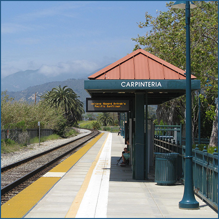
The Amtrak stop in Carpinteria opened in 1997 and consists of a concrete platform with a open-air shelter to protect passengers from inclement weather. It serves the popular Amtrak Pacific Surfliner route that travels between San Luis Obispo and San Diego via Los Angeles Union Station; easy connections are also available with local Santa Barbara Metropolitan Transit District buses. The station is conveniently located only a short walk from the Linden Avenue commercial district and Carpinteria State Beach.
The California coast was first explored by Juan Rodriguez Cabrillo who worked for the Kingdom of Castile. In 1542 he claimed the region for Spain, but no settlements were planned; 60 years later the coast was mapped by Sebastián Vizcaíno. Although known by the Spaniards for more than 200 years, they did not establish settlements in California until the late 18th century when the Russian Empire began to take an interest in the area.
To secure the coast, King Carlos III authorized the creation of a chain of forts and missions to protect strategic sites that could be of future use to the Spanish Empire in North America. The first “presidio” or “fort” and mission complex was established at San Diego in 1769. The Franciscan missionaries worked toward the conversion of the region’s American Indians to Christianity, a stated goal of Spanish colonization.
In 1786, a mission was founded 12 miles to the northwest of Carpinteria at Santa Barbara. Each mission was supported by large tracts of land for agriculture and grazing that were worked by the friars and the converts; much of the land in the Santa Barbara and Carpinteria vicinity once belonged to the mission. The grasslands of the Carpinteria Valley hosted cattle, sheep, and goats while the fields closer to the mission complex produced wheat, barley, beans and peas. The friars also cultivated orange and olive trees.
At the time of Spanish colonization, the coastal area was occupied by the Chumash American Indians. Their name meaning “bead makers/seashell people,” the Chumash lived in an area stretching from the Pacific Ocean to the Santa Susana Mountains. They were among the few American Indian peoples to navigate the coast by ocean-going vessel. Mariners constructed “tomols,” canoes that were water-proofed with pine pitch or tar, and historic accounts recall that a group of Chumash went out to sea to observe Cabrillo when he sailed up the coast.
A Spanish exploration party looking for suitable presidio and mission sites came upon a Chumash settlement and called it “Carpintería” or “carpentry shop” because of the tomols that were under construction; the area lent itself to this activity because of the availability of wood and natural tar deposits. The Chumash were also noted for their woven baskets and stone cookware used to prepare meals.
Much of the coast at Carpinteria was covered by a salt marsh, part of which still exists to the west of the present town. The brackish waters, fed by a number of freshwater creeks and subject to ocean tides, were home to fish and birds which in turn attracted larger game such as deer and coyote that came down from the foothills in search of food. A Chumash village referred to as “Mishopshno” stood near the marsh. Translating to “correspondence,” the name was appropriate because the settlement was a regional center of trade for the peoples living along the coast.
After Mexico gained independence from Spain in 1821, most of the mission properties were secularized and broken-up into multi-thousand acre “ranchos” or ranches that were often granted to the friends and family members of important Mexican officials such as the governor. The land grants survived into the American period following the Mexican-American War of 1845-1848 and the resulting cession of California and much of the Southwest to the United States.
Unlike other parts of the coast where large ranchos were carved out of the land, the Carpinteria area was divided up into small farms of a few hundred acres; a settlement formed about one mile west of the center of present-day Carpinteria. Mexican-American families and settlers attracted to California from the East experimented with numerous crops to discover those best suited to the climate, including lima beans, flax, squash, wheat, and barley; an early guidebook recalls the valley’s honey. Lima beans became a staple, and by the end of the century an average of 800 tons was produced every year. A wharf at nearby Serena allowed for the shipment of agricultural products to large cities along the coast, as well as the importation of needed finished goods.
One of the most prominent early settlers was Russell Heath. Arriving in Santa Barbara County in 1853, he had a long career that included stints as county sheriff, district attorney, and a legislator. In 1858 he moved to the Carpinteria Valley to practice agriculture, and he became especially known for his extensive grove of English walnut trees. The ruins of Heath’s adobe house are still visible in a park named for him and located in the northwestern part of town. It is a local landmark and one of the sole tangible reminders of the early American period.
Although an official federal presence was established in 1868 when Carpinteria received a post office, it was not until 1887 and the arrival of the railroad that the settlement was really put on the map. Wedged on a tight strip of land between the Pacific Ocean and the majestic Santa Ynez Mountains, access to the valley had been difficult and further complicated by the presence of the salt marsh. Much travel actually occurred at low tide when the broad beach was left exposed and could be traversed to reach Ventura and other seaside villages.
The Southern Pacific Railroad (SP) completed tracks into Carpinteria from the southeast in late June 1887; the right-of-way skirted the northern edge of the salt marsh. Within two weeks, scheduled service began to Los Angeles, connecting the small agriculture village to southern California’s growing metropolis. In 1876, the SP had opened a tunnel through the Newhall Pass northwest of Los Angeles at San Fernando. In 1886, the railroad decided to build a spur from the Newhall Pass to Ventura and then onto Santa Barbara via Carpinteria. The “Coast Line” was intended to eventually reach San Francisco; this did not occur until 1901, but once completed, Carpinteria found itself on the main route between the state’s two biggest cities.
The SP soon erected a depot at the intersection of Linden Avenue and Fifth Street to serve passengers. Railroads often built stations to a standardized design in communities of comparable size; therefore, Carpinteria’s depot resembles those at Ventura and Moorpark to the southeast, and is a combination station in which the passenger and freight areas were “combined” under one roof.
The main section of the depot, housing the waiting room and the station-master’s office, was two stories high and featured a hipped roof; a one-story addition extended from the depot along the tracks and housed the freight room. A projecting bay on the two story section faced the tracks and had windows on all three sides. This design allowed the station-master to monitor traffic up and down the line from his office. The second floor of the depot was a private apartment for the station-master and included bedrooms and a kitchen; living quarters were often included in depots located in rural areas.
A deep eave encircled the two story section between the first and second floors and was designed to protect passengers waiting outside from the sun and rain. The freight room had a simple gabled roof with deep eaves that helped keep the freight dry as it was loaded or offloaded from the trains during rain storms. At one story, the freight room had wide sliding doors that accommodated large crates and packages, and it lacked windows to increase security. A loading dock raised off the ground allowed materials to move seamlessly between the cars and the freight room all on the same elevation. Soon after it was built, the wood clapboard of the depot was likely dressed in a standard coat of the SP’s “Colonial Yellow” paint with the trim in a dark brown.
By the mid-20th century, when federal and state spending shifted to highways and aviation, passenger railroads began to cut routes and train frequencies. Similar to many other small towns, Carpinteria lost its SP service. The depot closed in 1958 and was torn down in 1967. The original sign that spelled out the town’s name is now in the collection of the Carpinteria Valley Museum of History, which strives to preserve and protect the region’s rich heritage.
The placement of the depot changed the form of Carpinteria and was a valuable chess piece in a larger game between Russell Heath and newer arrival H.J. Laughlin. Heath assumed that the railroad would build the depot in Old Town where he owned much of the land, but Laughlin lured the SP eastward with the promise of a very cheap parcel. Old Town eventually shrank and was forgotten as its residents moved to the new section of town laid out around the depot. Linden Avenue became the town’s “main street” and ran from the beach to the foothills. As the street grid was populated, the eastern portion of the salt marsh began to silt up and was later filled in to create buildable lots.
Rather confident in his ability to influence the location of the depot, Laughlin began building a hotel on Linden Avenue in 1886, and it opened to the public in January of the following year. He hoped to attract tourists to his modern facility that included healthful sulphur spring baths; the building only stood until 1894 when it was claimed by fire. Although the building is gone, the famous palm trees that Laughlin planted along Linden Avenue remain. They still stand tall and orderly as a character-defining feature of the landscape, so much so that they have been designated a local historic landmark. Laughlin had some competition in Shepard’s Inn, a collection of cottages that attracted the likes of Teddy Roosevelt, movie starlet Mary Pickford, and tenor Enrico Caruso for fine dining and opportunities to fish and hunt in the marsh and the nearby mountains.
Despite the star appeal of Shepard’s Inn, Carpinteria remained primarily agricultural. The soil on this portion of the southern California coast was recognized for its richness; combined with the even, temperate climate, the land was ideal for the cultivation of fruits such as strawberries, oranges, and lemons. Once the railroad arrived, the perishable fruits could be quickly shipped across the country. In the first decades of the twentieth century, lima beans and lemons were Carpinteria’s principle products and sources of prosperity. The town’s lima beans—the Carpinteria Fordhook—produced descendents across the world through the work of the Henry Fish Seed Company. Lemons would be grown well into the 1960s until they were replaced by avocados.
The natural asphaltum oozing to the surface was gathered in the late 19th century and used to pave roads in Carpinteria and as far away as Los Angeles and San Francisco. Geologists searching for petroleum later recognized that the presence of asphaltum probably meant that oil was nearby, and subsequently the coast from Ventura to Goleta was explored for “black gold” starting in the late 1910s. Carpinteria boasted some wells, but its neighbors fared better in this respect.
The Coastal Highway was expanded and improved in the 1920s, and brought in tourists who were attracted to Carpinteria’s beach, advertised as the “World’s Safest” due to its width, shallowness of the water, and distance from the breaking surf further out at sea . As early as 1920, a guidebook noted that the “Hawaiian diversion of surf-board riding” could be enjoyed at Carpinteria, and Rincon Point to the southeast of town remains a world-famous surf spot. It was even celebrated in the 1962 Beach Boys hit “Surfin’ Safari.”
Post-World War II, California’s population underwent explosive growth and Carpinteria developed as a residential community. In the tradition of its agricultural past, the town is home to numerous floral enterprises that encompass extensive greenhouses and fields along the northern and western edges of town. Avocados are still a big business in the county, and Carpinteria holds an annual Avocado Festival in early October. More than 100,000 visitors throng the pretty streets of downtown to celebrate the green fruit and learn the many ways in which it can be enjoyed. Live music, food stands, and craft booths round out the event. Attendees can also poke their heads into the shops and galleries along Linden Avenue.
Those interested in the coast’s natural beauty can spend a day exploring its unique ecosystems. Migrating birds gather at the Salt Marsh Nature Park which also has nature paths and spots from which to observe the animal activity in the estuary. The 52-acre Carpinteria Bluffs not only offer amazing views to sea and mountains, but also contain the Harbor Seal Preserve. In winter and early spring, the adults give birth to and attend to their young on the beach. Visitors can watch the animals in their native habitat, but they are encouraged to do so from a respectful distance. In homage to these mammals, a fountain on Linden Avenue features a playful seal as its centerpiece, and is popular with the kids. Carpinteria State Beach, in addition to popular campgrounds, also features a rocky tide pool area populated by sea stars, anemones, crabs, and other creatures.
The Pacific Surfliner service is primarily financed through funds made available by the State of California, Department of Transportation, and is managed by the LOSSAN Joint Powers Authority.
Platform with Shelter
Features
- ATM not available
- No elevator
- Payphones
- No Quik-Trak kiosks
- No Restrooms
- Unaccompanied child travel not allowed
- No vending machines
- No WiFi
- Arrive at least 30 minutes prior to departure
Baggage
- Amtrak Express shipping not available
- No checked baggage service
- No checked baggage storage
- Bike boxes not available
- No baggage carts
- Ski bags not available
- No bag storage
- Shipping boxes not available
- No baggage assistance
Parking
- Same-day parking is available; fees may apply
- Overnight parking is available; fees may apply
Accessibility
- Payphones
- Accessible platform
- Accessible restrooms
- No accessible ticket office
- No accessible waiting room
- No accessible water fountain
- Same-day, accessible parking is available; fees may apply
- Overnight, accessible parking is available; fees may apply
- High platform
- No wheelchair
- Wheelchair lift available
Hours
Station Waiting Room Hours
Ticket Office Hours
Passenger Assistance Hours
Checked Baggage Service
Parking Hours
Quik-Track Kiosk Hours
| Mon | 24 HOURS |
| Tue | 24 HOURS |
| Wed | 24 HOURS |
| Thu | 24 HOURS |
| Fri | 24 HOURS |
| Sat | 24 HOURS |
| Sun | 24 HOURS |