
Bakersfield, CA (BFD)
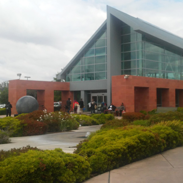
With vast walls of glass and a striking veneer of warm, rich India red sandstone, the station welcomes travelers with a series of jaunty water jets surrounded by native plants.
601 Truxtun Avenue
Bakersfield, CA 93301-5319
- Facility Ownership: City of Bakersfield
- Parking Lot Ownership: City of Bakersfield
- Platform Ownership: City of Bakersfield
- Track Ownership: City of Bakersfield
Alex Khalfin
Regional Contact
governmentaffairsoak@amtrak.com
For information about Amtrak fares and schedules, please visit Amtrak.com or call 1-800-USA-RAIL (1-800-872-7245).
The Amtrak stop in Bakersfield is located southeast of downtown and adjacent to the Beale Memorial Library and the convention center. Amid much celebration, the current Bakersfield intermodal center opened on July 4, 2000, to a crowd of more than 2,000 visitors who came to tour the facility. Featured guests included the mayor, a state senator, and Amtrak officials, and attendees were treated to the sounds of singer Buck Owens—a famed musician known as a strong proponent of the “Bakersfield Sound”—a style of country music unique to the southern San Joaquin Valley. Amtrak also brought in a display train for visitors to explore; it broke through a ceremonial banner as it pulled up to the platform.
The contemporary $5.1 million station was funded by the state of California, and was one piece of a complex, coordinated construction project that included placing a portion of an irrigation canal into an underground pipe and building an underpass beneath the Burlington Northern Santa Fe (BNSF) tracks in order to improve downtown traffic flow. The state requested that the city of Bakersfield lead the project, and additional input was sought from the Kern Council of Governments, Caltrans, BNSF, and Amtrak. Upon completion, the development won a number of awards such as the American Public Works Association’s Public Works Project of the Year.
On the west end, the intermodal center provides a loading area for local and regional busses that features a wide canopy to protect travelers from the sun and inclement weather; a taxi stand is located directly to the north. This vehicle zone is separated from the 8,300 square foot station by a landscaped parcel with native plants that require minimal or no irrigation. The vegetation frames a series of jaunty water jets that sway in the breeze and create a sense of excitement upon arrival. To the east, the landscaping continues on the south side of the station and acts as a buffer between the building and the platforms, one of which is also sheltered by a long canopy.
Designed by Los Angeles-based Rossetti Associates Architects, the Bakersfield station is a modern structure with vast walls of glass and a striking veneer of warm, rich India red sandstone laid in a coursed ashlar pattern. As the sun crosses the sky, the varying color tones of the stone are highlighted. From a distance, the building is easily understood as three distinct parts. To the west is the public waiting room marked by an angular roofline. A three story rectangular tower marks the transition to the private administrative area—offices and baggage handling—located at the eastern end of the building which is crowned with a gently curving roof.
Passengers approach the building from the west and enter into a forecourt with a large fountain featuring a model of the earth; the large stone sphere appears to be held aloft by a strong current of water that wells up from the pool at the base. The arms of the forecourt are extensions of the bulky, stylized colonnades that form the walls of the waiting room. Above, a grid of rectangular glass panels rises to the ridge of the roof. Its height is further emphasized by a metal partition that runs to the ground and creates a strong vertical axis.
The glass grid continues along the enclosed colonnades to the back wall of the waiting room which is one side of the three storey tower. Varying in height along the north and south facades, the glass grid makes for a dramatic roofline that is underscored by exposed framing. The ridge of the roof is marked by a skylight that runs the length of the waiting room; between it and the clerestory windows, the passenger areas are flooded with natural light throughout the day. At the far end of the space, an abstract clock face is mounted on the tower wall above the ticket counter.
The new station was built about one mile east of the old prefabricated depot that had been erected for the initiation of Amtrak San Joaquins service in 1974. The small building had become too crowded as demand for passenger rail service in California expanded throughout the late 20th century. On November 3, 2025, the Amtrak San Joaquins was rebranded to Gold Runner. Introduced by the San Joaquin Joint Powers Authority, which is responsible for the management and administration of the service, the name unites rail and Thruway bus service under a single, cohesive identity. The Gold Runner name reflects both the heritage and momentum of the Central Valley, representing speed, connection and California pride.
Bakersfield is located at the southern end of the San Joaquin Valley and north of the Tehachapi Mountains that separate the valley from the Mohave Desert to the southeast and the greater Los Angeles metropolitan area to the south. Thanks to its position near the two passes over the mountains—the Tejon and Tehachapi—the town had the potential to become an important transportation hub. Spanish explorers such as Father Francisco Garces traveled through the area in the late 18th century. He encountered tribes belonging to the larger American Indian group referred to as the Yokut who were spread throughout the San Joaquin Valley.
The valley was not settled by European-Americans until the 1820s. After Mexico gained independence from Spain in 1821, much of the land in southern California was broken up into large estates that were often doled out to friends of those in power. Although isolated from populated coastal areas due to the mountain ranges, the San Joaquin Valley was used for grazing. The Gold Rush of 1849 attracted adventurers to California from other parts of the country. Many dreams of gold came to naught but the settlers remained in the west and started to build lives. Subsequently, many of the Yokut were driven off their land and onto designated reservations.
Traversing the Tejon Pass through the Tehachapi Mountains, a handful of families permanently settled in the Bakersfield area in the 1850s; others soon followed with the discovery of gold in the valley. Early accounts describe the territory as marshy and watered by the flow of the Kern River. The banks of the streams and shallow lakes were marked by willows and beds of tule that provided a nourishing habitat for many animals such as fish and water foul. The wetlands were extensive enough that the first houses were located on what was called “Kern’s Island.”
In 1863, Colonel Thomas Baker made his way south from Visalia. Similar to many western pioneers, Baker had continually moved west in search of new opportunities. Born in Ohio in 1810, he spent many years in Iowa before making his way to California in 1850. Prior to his arrival at Kern’s Island, he had served in the new state legislature from 1861 to 1862. He obtained a reclamation right from the state for much of the wetlands that today hold downtown Bakersfield. Digging a series of canals, Baker drained the land and prepared it for agriculture, while also building a home. One story behind the naming of the town recalls that Baker was known for his good nature and hospitality. Eventually, Kern’s Island was referred to as “Baker’s Field” which morphed into “Bakersfield” when the town was officially founded in 1869.
Barley, wheat, and flax grew well in the fertile soil, and farmers experimented with subtropical fruits like their counterparts on the coast. Although the efforts of farmers yielded good crops, the lack of access to markets dampened economic activity. Thanks to Colonel Baker, who had constructed a road from the town to the county seat at Havilah, the settlement had access to the stagecoach lines that ran to Owen’s River and Los Angeles, but it was not until the arrival of the railroad in 1874 that Bakersfield truly opened to growth.
Early railroading in California was dominated by the Southern Pacific Railroad (SP). By the early 1870s, the SP—and the Central Pacific Railroad (CP), which it controlled—were working on a line that would run down the valley to connect San Francisco and Los Angeles. Bakersfield leaders were confident that the line would come to their community due to the city’s pivotal location at the bottom of the valley. Years of anticipation paid off in 1874 with the completion of the SP bridge over the Kern River and the introduction of rail service that October. The link to Los Angeles was not forged for another two years until the tunnel through the Newhall Pass finally opened.
The SP laid the tracks to the east of Bakersfield and the new town of Sumner sprung up to take advantage of proximity to the railroad; in 1910, Sumner would be subsumed by its neighbor and is today known as East Bakersfield. In 1889, a large SP depot opened at the corner of Sumner and Baker Streets, where it still stands. Remodeled many times, the building incorporates many architectural styles. Its defining feature is a long, shady arcade that stretches along the tracks. The building has not been open to passengers in decades, but it is used by the Union Pacific Railroad—which purchased the SP in 1996—as a crew change center and office space.
New growth ushered in by the railroad empowered Bakersfield to wrest the county seat away from Havilah in 1873. The climate and abundant water resources of the southern valley were ideal for cotton and acres of the fiber were planted in the 1870s; once harvested, it was sent to San Francisco to be spun into thread and cloth. To facilitate large scale agriculture, landowners enlarged the canal system to guarantee a steady water supply for irrigation.
In the 1890s, the San Francisco and San Joaquin Valley Railroad (SF&SJV) was proposed as an alternative to the SP’s monopoly on rapid transportation in the region; farmers especially desired a more competitive arrangement for shipping their products. The Atchison, Topeka, and Santa Fe Railroad (ATSF) had entered southern California in the 1880s and presented itself as the SP’s main rival. By purchasing the SF&SJV upon completion in 1899 and gaining trackage rights over the SP’s Tehachapi line, the ATSF gained passage through the San Joaquin Valley and provided Bakersfield with an additional rail connection. A depot and Harvey House facility—a restaurant and café chain closely allied with the ATSF throughout the West—were built adjacent to the rail yard at 15th and F Streets. Although the depot and Harvey House were torn down in December 1972, the yard is still used by the BNSF, successor to the ATSF.
In the southern part of the valley, natural oil deposits had seeped to the surface for centuries; the gooey liquid had been used by the Yokut to waterproof baskets. The development of the automobile industry at the end of the 19th century created a sustained demand for petroleum products and in 1899 the first well was sunk north of the city. Derricks soon dotted the landscape and the SP built a branch line to carry the oil to San Francisco. Within a decade, Kern County was producing about one-eighth of the world’s petroleum. The rapid development of the oil industry demanded workers, and many early residents migrated from Texas, Louisiana, and Oklahoma which were also known for their oil fields.
A century later, agriculture and oil remain the area’s major businesses, and Bakersfield has grown into one of the largest cities in California. The mild climate allows for a diverse array of crops, including almonds, pistachios, citrus, and roses. Kern County is still one of the top oil producing areas in the nation and consequently many oil and gas companies have their regional headquarters in town.
Bakersfield’s exciting past is rather tangible at the Kern County Museum. Founded in 1941, its main attraction is a “village” composed of important historical structures from across the county. Visitors may walk the streets and have a look in a log cabin, dentist’s office, or even a chuck wagon. Railroad related structures include a SP jail that was used while the railroad laid track through the county. Railroad camps could be tough and rowdy settlements, and crime was a serious problem. The Bena depot once stood a few miles west of the famed Tehachapi Loop, an engineering marvel constructed by the SP from 1874 to 1876. To cross the mountains, the track looped over itself, and the line included 18 tunnels and ten bridges constructed primarily through the labor of Chinese immigrants. The Tehachapi Loop remains a favorite haunt of rail enthusiasts and is still in constant use. For many years, the Bena depot was used for freight shipments and operated as a telegraph station. Across the walkway is a small ATSF scale house that once stood in the switch yard near the Harvey House.
Museum goers may also explore an exhibition on oil that shows how it is geologically created and then mined, refined, and used in modern industry. The displays provide insight into the lives of those who work in the oil industry and how technology has changed their jobs over the last century. Country music fans usually flock to the cabinets filled with memorabilia that traces the evolution of the “Bakersfield Sound.” Developed in the 1950s and 1960s, the country music genre is characterized by a rock-and-roll edge such as the use of electric guitars and intense vocals.
The Gold Runner service is primarily financed through funds made available by the State of California, Department of Transportation, and is managed by the San Joaquin Joint Powers Authority.
Station Building (with waiting room)
Features
- ATM available
- Elevator
- Payphones
- Quik-Trak kiosks
- Restrooms
- Ticket sales office
- Unaccompanied child travel allowed
- Vending machines
- No WiFi
- Boarding gates close 5 Min before train departure time
- Arrive at least 45 minutes prior to departure if you're checking baggage or need ticketing/passenger assistance
- Arrive at least 30 minutes prior to departure if you're not checking baggage or don't need assistance
Baggage
- Amtrak Express shipping not available
- Checked baggage service available
- Checked baggage storage available
- Bike boxes for sale
- Baggage carts available
- Ski bags not available
- Bag storage with Fee
- Shipping Boxes for sale
- Baggage assistance provided by Station Staff
Parking
- Same-day parking is available for free
- Overnight parking is available for free
Accessibility
- Payphones
- Accessible platform
- Accessible restrooms
- Accessible ticket office
- Accessible waiting room
- Accessible water fountain
- Same-day, accessible parking is available; fees may apply
- Overnight, accessible parking is available; fees may apply
- No high platform
- Wheelchair available
- Wheelchair lift available
Hours
Station Waiting Room Hours
| Mon | 03:45 am - 09:00 pm |
| Tue | 03:45 am - 09:00 pm |
| Wed | 03:45 am - 09:00 pm |
| Thu | 03:45 am - 09:00 pm |
| Fri | 03:45 am - 09:00 pm |
| Sat | 03:45 am - 09:00 pm |
| Sun | 03:45 am - 09:00 pm |
Ticket Office Hours
| Mon | 04:40 am - 08:30 pm |
| Tue | 04:40 am - 08:30 pm |
| Wed | 04:40 am - 08:30 pm |
| Thu | 04:40 am - 08:30 pm |
| Fri | 04:40 am - 08:30 pm |
| Sat | 04:40 am - 08:30 pm |
| Sun | 04:40 am - 08:30 pm |
Passenger Assistance Hours
| Mon | 04:40 am - 08:30 pm |
| Tue | 04:40 am - 08:30 pm |
| Wed | 04:40 am - 08:30 pm |
| Thu | 04:40 am - 08:30 pm |
| Fri | 04:40 am - 08:30 pm |
| Sat | 04:40 am - 08:30 pm |
| Sun | 04:40 am - 08:30 pm |
Checked Baggage Service
| Mon | 04:40 am - 08:30 pm |
| Tue | 04:40 am - 08:30 pm |
| Wed | 04:40 am - 08:30 pm |
| Thu | 04:40 am - 08:30 pm |
| Fri | 04:40 am - 08:30 pm |
| Sat | 04:40 am - 08:30 pm |
| Sun | 04:40 am - 08:30 pm |
Parking Hours
Quik-Track Kiosk Hours
| Mon | 03:45 am - 09:00 pm |
| Tue | 03:45 am - 09:00 pm |
| Wed | 03:45 am - 09:00 pm |
| Thu | 03:45 am - 09:00 pm |
| Fri | 03:45 am - 09:00 pm |
| Sat | 03:45 am - 09:00 pm |
| Sun | 03:45 am - 09:00 pm |
Lounge Hours
Amtrak Express Hours
| Mon | CLOSED |
| Tue | CLOSED |
| Wed | CLOSED |
| Thu | CLOSED |
| Fri | CLOSED |
| Sat | CLOSED |
| Sun | CLOSED |