
Santa Ana, CA (SNA)
The transportation center includes a waiting area for rail and bus passengers, event space and offices. Its Mediterranean Revival design features arcades, decorative tile and a coffered ceiling.
1000 East Santa Ana Boulevard
Santa Ana, CA 92701
- Facility Ownership: City of Santa Ana
- Parking Lot Ownership: City of Santa Ana
- Platform Ownership: City of Santa Ana
- Track Ownership: Orange County Transportation Authority (OCTA)
Alex Khalfin
Regional Contact
governmentaffairsoak@amtrak.com
For information about Amtrak fares and schedules, please visit Amtrak.com or call 1-800-USA-RAIL (1-800-872-7245).
Completed in 1985 as part of a state effort to establish and grow a commuter rail system in southern California, the Santa Ana Regional Transportation Center (SARTC) is located east of downtown on seven acres. At the time, it was one of the largest train stations built since the mid-20th century. In addition to space for rail and bus passengers, the building also houses conference and event space as well as the Santa Ana WORK Center which provides job and workforce development services. The $17 million project was funded from the following sources: $2 million from the U.S. Department of Transportation; $4.5 million from the California Department of Transportation; and the remainder from the city, including $6.2 million in redevelopment bonds.
The station was designed in a Mediterranean Revival style that complements much of the region’s older building stock. The height of the structure varies from two to five stories. Exterior walls are whitewashed to give the appearance of stucco, the roofs are laid in red Spanish tile, and a light brown stone is used for trim such as the starburst window above the main entrance. Spanish and Mission Revival architecture became quite popular in southern California starting in the late 19th century. Civic boosters promoted the related aesthetics as a way to tie to the state’s Spanish past, which was romanticized in order to attract settlers and to create a regional identity.
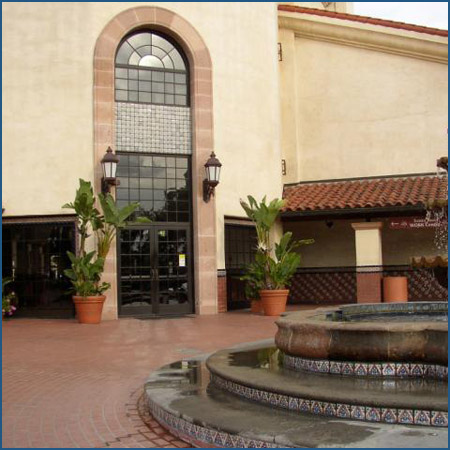
The building forms an “L” in which the two wings back up onto the tracks, creating a sheltered plaza that is framed by shady colonnades. At the corner where the two wings meet, a prominent five story, twelve-sided tower indicates the location of the main entrance. The lower portions of the tower are almost completely solid, but this visual heaviness is lightened at the top where a row of round arch clerestory windows enliven the façade and draw attention to the tent-like roof. Approaching from Santiago Street, a long colonnade lined by stately palms draws the eye to the front doors and helps to form an entrance forecourt.
The Mediterranean Revival language continues on the interior which features wainscot of red clay tile accented with azulejos (painted tiles) in blue, yellow, and white. Entering the tower, one notices the diffused light that streams through a delicate skylight at the top of the shaft. Round arches frame the ticket area and waiting room which is crowned with a dark and lustrous coffered ceiling made of wood; the cross beams showcase the typical carving found in early California buildings such as the Spanish missions. Wood benches are also based on colonial precedents with swirling Baroque motifs.
Large arched doorways open onto the colonnades that line the patio that leads from the building to the platforms. The tile wainscot continues onto the covered walkways and alternating columns act as the backdrop for tall clay planters from which luxurious vines climb toward the roof. At one end, a sweeping, broad staircase with a stone balustrade and hand rail elegantly ascends to the second floor colonnade and terrace that act as extensions of the conference and event spaces. The risers of the staircase are covered in azulejos that create a vibrant zig-zag pattern in red, yellow, green, and blue. On the far side of the plaza, there is a bridge that allows passengers to cross the tracks to the opposite platform.
The California coast was first explored by Juan Rodriguez Cabrillo who worked for the Kingdom of Castile. In 1542 he claimed the region for Spain, but no settlements were planned; 60 years later the coast was mapped by Sebastián Vizcaíno. Although known by the Spaniards for more than 200 years, they did not establish settlements in California until the late 18th century when the Russian Empire began to take an interest in the area.
To secure the coast, King Carlos III authorized the creation of a chain of forts and missions to protect strategic sites that could be of future use to the Spanish Empire in North America. The first “presidio” or “fort” and mission complex was established at San Diego in 1769; that same year, the explorers passed through a beautiful valley that they named “Santa Ana” in honor of Saint Anne. In 1771, the Franciscan friars charged with running the missions established a community thirty miles to the northwest of present day Santa Ana at San Gabriel, and in 1775 another mission was begun 23 miles to the southeast at San Juan Capistrano. The Franciscans worked toward the conversion of the region’s American Indians to Christianity, a stated goal of Spanish colonization. Each mission was supported by large tracts of land for agriculture and grazing that were worked by the friars and the converts.
American Indians were willingly or sometimes forcibly settled at the missions where the friars provided instruction not simply in religion, but also in crafts and skills such as tanning or woodworking. Those associated with Mission San Gabriel Arcángel were referred to as “Gabrieliño (“of Gabriel”). According to historic accounts, the Gabrieliños had populated the area encompassing present day Santa Ana, and called themselves Tongva, meaning “people of the earth.”
San Juan Capistrano and San Gabriel Arcángel became large and wealthy missions, and the inhabitants grew grains and beans and raised livestock. Following Mexico’s independence from Spain in 1821, the missions were secularized and many of the buildings and land holdings were sold off to private owners, who created large “ranchos” or ranches used primarily for sheep and cattle grazing. Many of the ranchos survived into the American period following the United States’ victory over Mexico in the Mexican-American War of 1845-1848 and the resulting cession of California and much of the Southwest to the United States.
Santa Ana’s name holds a clue to its past: it refers to the historic Spanish colonial rancho on which the town site is located. Rancho Santiago de Santa Ana was one of the only landholdings granted by the Spanish authorities to an individual owner. Juan Pablo Grijalva, a soldier who participated in the first Spanish forays into the area, began grazing cattle in the area in the 1780s and subsequently requested the territory. Grijalva died before he gained title, but eventually the land was granted in 1810 to his son-in-law Jose Antonio Yorba and his grandson Juan Pablo Peralta. The two men raised cattle, sheep, and goats and also grew grains on the 62,000 acre estate that stretched twenty-five miles between the ocean and the mountains.
In 1854, the Yorbas sold the rancho to José Andrés Sepúlveda who also owned lands formerly held by Mission San Juan Capistrano. Together his properties were called Rancho San Joaquin and accounted for almost 50,000 acres from the coast to the foothills of the Santa Ana Mountains. The Gold Rush of 1849 was especially fruitful as the miners brought appetites which Sepúlveda and other ranchers satisfied by driving their herds north. Sepúlveda was known too for his lavish lifestyle including fine clothes and a home that hosted many a party such as his daughter’s 45 day-long wedding fiesta. A fine equestrian, he won a race in 1852 against a former Mexican governor of California that netted him $25,000 in gold and hundreds of animals.
As the years passed, Sepúlveda amassed a considerable debt through gambling losses and legal fees associated with the process of establishing title to his land under the new American administration. Droughts in the early 1860s further damaged his businesses and he was forced to sell the majority of his Orange County property. 74.25 acres covered in mustard plants and cacti were purchased for $594 by William Spurgeon and Major Ward Bradford in 1869 to establish a town. While both men initially founded the town, which they called “Santa Ana” in honor of the old rancho, Major Bradford later moved onto other enterprises to the south in San Diego County; therefore, Spurgeon is considered the “founding father” of Santa Ana. The earliest structures in town included Bradford’s house and Spurgeon’s mercantile store, constructed of redwood.
Spurgeon, who had spent most of his childhood in Missouri, first came to California during the Gold Rush of 1849 like so many other young men seeking fortune. After four years, he returned to the Midwest only to be lured back again in the mid-1860s. On his third trip, he made his major land purchase and committed his energies to promoting Santa Ana. Spurgeon’s community faced competition from nearby Tustin and then Orange; to encourage settlement in Santa Ana, Bradford and Spurgeon often gave away lots on the condition that new arrivals quickly improve the land with a house or commercial structure. Spurgeon wisely lured the Los Angeles-San Diego stagecoach from Tustin to Santa Ana by cutting a road through the scrub. A post office then opened, and he acted as postmaster. Spurgeon also funded the all-important well to supply early residents with drinking water. He was recognized by later generations for having played a fundamental role in just about every organization or event in early Santa Ana.
By the 1870s, Spurgeon was wooing the railroads, and he sold part of his own property to the Southern Pacific (SP) and later the Atchison, Topeka, and Santa Fe Railroads (ATSF). At the time, Los Angeles and San Francisco dominated Californian shipping and railroading. The foremost railroad in the state was the SP, which wanted to build a line south to connect to San Diego before the rival ATSF, then laying track through the Southwest, made it to the West Coast. Spurgeon negotiated with the SP to move its southern terminus from neighboring Anaheim to Santa Ana in 1877. The wood depot built along E. Fruit Street was a two-storey structure with decorative but simple wood trim, and the structure was crowned with a broad, gabled roof. Behind the main building was a one-storey freight house with wide doors that allowed for the efficient movement of crates and packages. For $2, residents could travel to Los Angeles—the roughly 30 trip took three hours.
With the laying of the tracks a few blocks east of downtown Santa Ana, Spurgeon and a few friends platted “Santa Ana East” next to the rail line with the expectation of attracting businesses, but few moved from the town center. By the turn of the century, the area northwest of the depot became French Park, a residential neighborhood of large lots and comfortable homes built in a variety of architectural styles. After falling on hard times in the mid-twentieth century, restoration of the houses and neighborhood began in the 1970s and today the area is a National Register Historic District.
Santa Ana later benefitted from the arrival of the ATSF in 1887, which built a depot near the SP complex. From 1880-1882, the California Southern (CS), an ATSF subsidiary, had driven a line northward along the coast through swamps and bogs from San Diego to Oceanside; from there it turned inward, crossing gullies and canyons that required numerous trestles and other infrastructure built by Chinese laborers. After years of building and lawsuits with the SP, the line reached Barstow in 1885. The route soon proved treacherous, as the portion through Temecula Canyon washed out in 1882 within a year of its opening.
Searching for a better path, the ATSF started to build the “Surf Line” that was to run through Orange County to meet the CS at Oceanside. It allowed a safer coastal link between San Diego and Los Angeles that avoided Temecula Canyon which washed out again in 1891 and was abandoned. To get to Oceanside, the CS needed passage through the Irvine Ranch which occupied miles of land stretching from the coast to the mountains. Where the Irvines had denied a right-of-way to the SP partially out of enmity towards one of that railroad’s primary shareholders, the ATSF gained its desired strip of land. The ATSF arrived in Santa Ana in 1887, and the next year the Surf Line reached Oceanside to complete the link between San Diego and Los Angeles. deep eaves that wrapped around the depot and protected passenger from the warm sun.
Boasting two rail connections, Santa Ana solidified its position as the area’s primary city. In 1889 Orange County was formed from southern Los Angeles County and Santa Ana became the county seat. It was a shopping destination for farmers and ranchers from the surrounding agricultural communities and a shipping point for their goods which included citrus, walnuts, and grains. A grand courthouse rose on a square that had been set aside by Spurgeon. Constructed of Arizona red sandstone on a base of local Temecula granite, the $100,000 building opened in 1901. Listed on the National Register of Historic Places and the California State Landmarks list, the structure has been restored and visitors may tour its beautiful interior spaces.
As the city continued to grow, the ATSF constructed a new depot in 1939 by the tracks at E. Fourth Street a little south of the SARTC. It was far different than its fancy Victorian predecessor, featuring three intersecting volumes designed in a pared down Spanish Revival style with whitewashed walls and red tile roofs. The waiting room was accessed through a porch with round arches reminiscent of those on the nearby colonial missions; a wide door further down the platform indicated the placement of the freight room. The railroad closed the building in the early 1980s, and a few years later, fire damage resulted in its demolition.
In the past decade, the city has followed in the footsteps of William Spurgeon by thinking comprehensively about its future. City leaders envision a new 94 acre mixed-use district around the SARTC that will encourage the use of public transportation. Citizens have expressed interest in new housing that accommodates various income levels and needs, a community center, and open space. A fundamental part of this vision is improved public transportation within Santa Ana that includes a new streetcar system that will run from the SARTC to neighboring Garden Grove via the Santa Ana Civic Center.
Downtown revitalization efforts have given birth to the Santa Ana Arts District, an eight block area anchored by the historic Santora Building. An exuberant Spanish Baroque Revival structure completed in 1929, its exterior surfaces are covered in intricate stone carvings. Once a high-end shopping arcade, its spaces have become studios, galleries, and restaurants that attract a wide spectrum of visitors, especially during the monthly studio and gallery open house. A few blocks away, the historic Yost Theater has undergone a renovation that transformed the 1913 movie theater into a performing arts and music venue that attracts top regional talent.
Many visitors also enjoy a day at the Bowers Museum north of downtown. Established in 1936, the institution features a diverse collection of world art and encourages exploration through lectures, art classes, and other education programs. In 1994, the Bowers opened the Kidseum, a facility that strives to make art and cultural activities accessible to children and their families.
The Pacific Surfliner service is primarily financed through funds made available by the State of California, Department of Transportation, and is managed by the LOSSAN Joint Powers Authority.
Station Building (with waiting room)
Features
- ATM available
- Elevator
- Payphones
- Quik-Trak kiosks
- Restrooms
- Unaccompanied child travel not allowed
- Vending machines
- No WiFi
- Arrive at least 45 minutes prior to departure if you're checking baggage or need ticketing/passenger assistance
- Arrive at least 30 minutes prior to departure if you're not checking baggage or don't need assistance
Baggage
- Amtrak Express shipping not available
- No checked baggage service
- No checked baggage storage
- Bike boxes not available
- No baggage carts
- Ski bags not available
- No bag storage
- Shipping boxes not available
- No baggage assistance
Parking
- Same-day parking is available; fees may apply
- Overnight parking is available; fees may apply
Accessibility
- Payphones
- Accessible platform
- Accessible restrooms
- Accessible ticket office
- Accessible waiting room
- Accessible water fountain
- Same-day, accessible parking is available; fees may apply
- Overnight, accessible parking is available; fees may apply
- No high platform
- No wheelchair
- Wheelchair lift available
Hours
Station Waiting Room Hours
| Mon | 06:45 am - 10:45 pm |
| Tue | 06:45 am - 10:45 pm |
| Wed | 06:45 am - 10:45 pm |
| Thu | 06:45 am - 10:45 pm |
| Fri | 06:45 am - 10:45 pm |
| Sat | 06:45 am - 10:45 pm |
| Sun | 06:45 am - 10:45 pm |
Ticket Office Hours
| Mon | CLOSED |
| Tue | CLOSED |
| Wed | CLOSED |
| Thu | CLOSED |
| Fri | CLOSED |
| Sat | CLOSED |
| Sun | CLOSED |
Passenger Assistance Hours
| Mon | CLOSED |
| Tue | CLOSED |
| Wed | CLOSED |
| Thu | CLOSED |
| Fri | CLOSED |
| Sat | CLOSED |
| Sun | CLOSED |
Checked Baggage Service
| Mon | CLOSED |
| Tue | CLOSED |
| Wed | CLOSED |
| Thu | CLOSED |
| Fri | CLOSED |
| Sat | CLOSED |
| Sun | CLOSED |
Parking Hours
Quik-Track Kiosk Hours
| Mon | 06:45 am - 10:45 pm |
| Tue | 06:45 am - 10:45 pm |
| Wed | 06:45 am - 10:45 pm |
| Thu | 06:45 am - 10:45 pm |
| Fri | 06:45 am - 10:45 pm |
| Sat | 06:45 am - 10:45 pm |
| Sun | 06:45 am - 10:45 pm |
Lounge Hours
Amtrak Express Hours
| Mon | CLOSED |
| Tue | CLOSED |
| Wed | CLOSED |
| Thu | CLOSED |
| Fri | CLOSED |
| Sat | CLOSED |
| Sun | CLOSED |