
Suisun-Fairfield, CA (SUI)
As its name indicates, the station serves both of its namesake communities, although it sits just inside the border of Suisun City. Much of the downtown and waterfront is accessible by foot.
- Facility Ownership: City of Suisun
- Parking Lot Ownership: City of Suisun, State of California
- Platform Ownership: Union Pacific Railroad
- Track Ownership: Union Pacific Railroad
Alex Khalfin
Regional Contact
governmentaffairsoak@amtrak.com
For information about Amtrak fares and schedules, please visit Amtrak.com or call 1-800-USA-RAIL (1-800-872-7245).
As its name indicates, the Suisun-Fairfield station serves both of its namesake communities, although the building sits just inside the border of Suisun City. Located at the head of Main Street, the station is accessible on foot from much of the historic downtown and waterfront; a pedestrian bridge spans the Union Pacific tracks to connect with the streets of Fairfield. The station is also easy to reach from Interstate 12, which crosses the tracks just north of the building.
In the late 1980s, the state of California decided to make significant investments in intercity passenger rail. With a service area that spans eight northern counties, the Capitol Corridor was inaugurated in 1991 and envisioned as an alternative to congested Interstate 80. Situated about halfway between San Francisco and Sacramento, the station is a popular stop for commuters heading to either city. It is also served by local and intercity busses, making it a true intermodal center.
Opened to the public in March 1914, the current station is the second depot to serve these towns. Although the first one survived the tremors of the great San Francisco earthquake of 1906, a few months later it succumbed to a fire that also destroyed about half of the city’s residential quarter. Temporary passenger facilities were set up in a box car while plans were drawn up for the new structure. The Southern Pacific Railroad (SP) intended to put the replacement depot in the same location as the original—where Solano Street dead-ends at the tracks—but Fairfield officials successfully argued that it should be relocated a few blocks to the north closer to where the borders of the towns met. Since 1869, the stop had been known as “Suisun,” but after the move, the station was referred to as “Suisun-Fairfield.”
The SP was known for employing standardized station designs that helped shape a visual identity for the railroad while also reducing the costs associated with architects’ fees and construction. The Suisun-Fairfield depot is one of two dozen “colonnade style” stations erected by the SP. The design takes its name from the Tuscan columns used in the long porch that stretches out along the platform. Beneath its wide roof, passengers are protected from the hot summer sun and the winter rains as they wait outside for the arrival of the train. The one-storey wood frame structure was covered in clapboard; from the elegant rounded bay facing the tracks, the station agent could look down the tracks to monitor traffic on the line.
Employed during the early 20th century, the colonnade style mixed elements of Colonial Revival and Arts and Crafts architecture. The former is apparent in the use of the Tuscan columns, which recall the simplicity of early federal architecture and a renewed interest in classical design and motifs. Nurtured in California around the turn of the century, the Arts and Crafts movement emphasized the use of natural materials and traditional building techniques that showed off the skills of master craftsmen. Materials and structure were to be put on display, such as in the station’s deep eaves with their exposed rafters.
In the 1990s, Suisun City undertook numerous projects to renew its downtown core and reinvigorate the waterfront. One of the earliest projects focused on the train station, which had fallen into disrepair in the 1970s and was abandoned. In an effort to create a more inviting gateway to town, the Suisun City Redevelopment Authority gained control of the structure and used state transportation funds to carry out a full rehabilitation.
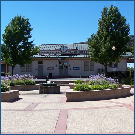
A new courtyard was installed between the station and Main Street to provide a landscaped approach to the building. The plaza not only increases the building’s visibility, but also offers passengers and residents a gathering place that includes seating, a fountain, raised beds with shrubs and flowers, and shade trees. Walking towards the station, visitors are greeted by a sign on the roof that sports the town name and a large clock face. In early 2012, a new café opened in the building.
In September 2016, representatives from the city, Solano County, the Solano County Transportation Authority and the Capitol Corridor Joint Powers Authority gathered to cut the ribbon on the depot’s latest rehabilitation. Using a grant from the Solano County Transportation Authority, the city completed work such as painting the interior, installing energy-efficient lighting and windows and refreshing the plaza and bus shelters.
As with many towns in northern California, Suisun City and Fairfield were founded in the Gold Rush era that commenced in 1849. Prior to the discovery of gold at Sutter’s Mill, much of present day California was lightly settled by Europeans—mostly Spaniards—who were gathered in coastal cities that had been established around Catholic missions or fortifications. The first explorers who made forays into the area around present day Suisun in the 18th century encountered bands of Patwin American Indians. Known as the “Suisunes”—meaning “People of the West Wind”—their name highlights the famous summer winds that sweep across the landscape. Nutrient-rich tule marshes supported large populations of fish and attracted migratory birds, thereby allowing opportunities for hunting. At the Rush Ranch south of town, school children may visit a recreated Patwin village with a tule hut and boat.
During the late 18th and early 19th centuries, the Spanish in the region had numerous encounters with the Suisunes, who offered shelter to American Indians who had run away from the Spanish missions. By the late 1810s, several groups of Suisunes were forced to live at missions Dolores and San Jose, located in San Francisco and Fremont, respectively. Others moved to Mission San Francisco Solano when it was established at Sonoma in 1823. Anasistencia, or ranch and farm meant to support the main mission, was founded by the Sonoma group to the west of current day Fairfield.
In the years following Mexico’s independence from Spain in 1821, most of the mission properties were secularized and broken-up into “ranchos” or ranches that were subsequently granted to the friends and family members of important Mexican officials. The lands belonging to Mission San Francisco Solano were placed under the control of General Mariano Vallejo, who was known for putting down American Indian revolts. In 1838, Vallejo provisionally granted approximately 18,000 acres to Francisco Solano, a Suisun who had been raised at the mission and who had assisted Vallejo in his campaign against the tribes. Known as the Rancho Suisun, the land grant encompassed most of present day Fairfield. Solano lived at the former asistencia until the property was formally conveyed to him in 1842, after which he then sold it to Vallejo for $1,000.
Gold fever changed everything. Fortunes were made and lost overnight. Speculation in land and other goods drove up prices, but the prospectors were a captive audience. In 1850, Archibald Richie, a San Francisco-based merchant, decided to purchase the Rancho Suisun and paid fifty times what Vallejo had received only a few years prior. Richie quickly subdivided the property and sold a one-third interest to Captain Robert Henry Waterman, who had been one of the great clipper ship captains of the time. Beginning his career as a cabin boy at the age of twelve, Waterman went on to sail to China and even designed the rigging of one of the earliest clipper ships. Prior to the completion of the transcontinental railroad in 1869, clipper ships, setting a course via the Strait of Magellan, were the fastest means of traveling between the east and west coasts of the United States.
Recognizing the need to feed hundreds of thousands of newly arrived gold seekers who constituted one of the largest voluntary mass migrations in human history, Waterman decided to establish a wharf at a point close to the road between Benicia and Sacramento. Agricultural products from Solano County could then be shipped out to growing cities via the region’s numerous bays, rivers, and sloughs. Waterman chose a spot which he called Bridgeport but later renamed Cordelia in honor of his wife. While adequate for shipping, Waterman’s venture was soon eclipsed by that of Josiah Wing, another former sea captain who had staked his future on the wealth of the land.
At the height of the Gold Rush, Wing set up a business to supply prospectors with the basic goods and provisions needed for the journey into the Sierra Nevada foothills. With his extensive nautical background, he soon began transporting passengers from San Francisco eastward to Sacramento, and consequently gained knowledge of the various waterways. In 1852, Wing spent $500 to purchase what he thought was an island, as well as 600 acres, just beyond Waterman’s property. Located at the navigable head of Suisun Slough, a wide and deep stream that cut through a large tule marsh, the island seemed an excellent site for establishing a wharf and warehouse for the storage of agricultural goods. Upon further investigation, the island turned out not to be one after all—at low tide, a spit of land connected it to the mainland.
To facilitate access to the wharf, Wing created a causeway by reinforcing the path through the bog with willow logs. Closer to local farming centers and easier to reach by boat, the new community—later known as Suisun City—flourished as a trading depot and quickly took away business from Cordelia. Wing experienced great success by transporting shiploads of grain. A steam mill was soon established to process wheat for local consumption. Within a decade of its founding, the town counted about 60 houses along its streets. In the summer of 1865, it was recorded that more than 8800 tons of wheat, 2700 tons of barley, and 24,000 packages of fruits and vegetables moved through the docks. Paving stones and marble from nearby quarries were also carted to town for export.
Not to be outdone, Waterman laid out a town on the mainland north of Suisun City in 1856. Named after his hometown of Fairfield, Conn, its growth was secured when two years later it was made the seat of rapidly growing Solano County. While Fairfield’s central location was a factor in the choice to move the administrative center there, Waterman’s offer of 16 acres for county buildings and a personal bond of $10,000 most likely swung the vote in his favor.
Over the years, the towns grew in tandem; Suisun became the commercial hub while Fairfield was home to government institutions and also noted for its residential neighborhoods. Life in Suisun City revolved around the central plaza, a hold-over from Spanish colonial town planning. The most important shops and trading houses were located along its edges and Sunday musicales were held at the gazebo in the park. Although Suisun and Fairfield were in close proximity to one another, they were physically separated by the marsh. The wood plank road, almost a mile long, remained the principle link. This divide between the two communities was only reinforced when the railroad was laid down between them in 1868. On June 24th of that year, an exhibition train was run over the line from Vallejo to Suisun. From an historic photo, the first Suisun depot appears to have been a one-story wood frame structure with a hipped roof and broad eaves. Accounts recall that by 1878, a hotel and restaurant had located nearby to accommodate travelers.
The original plan for the western portion of the transcontinental railroad called for the Western Pacific Railroad to build the 140 mile section between Sacramento and Oakland. In 1865, the California Pacific Railroad (Cal-P) was incorporated with the purpose of constructing a competing line from Sacramento to Vallejo. Located where the western end of the Carquinez Strait meets San Pablo Bay, Vallejo became a transfer point where passengers and goods could be moved from railcars to a ferry in order to continue on to San Francisco. The proposed route was only 90 miles and therefore quicker and more convenient than the Western Pacific. Subsequently, the Western Pacific’s allies at the Central Pacific (CP) attempted to stop the Cal-P from making its way into Sacramento. Ultimately unsuccessful in its efforts, the CP bought out the upstart a few years later.
In 1879, the CP finished construction of a new route from Suisun City to Benicia, a town located on the eastern end of the Carquinez Strait. While more direct and shorter than the path to Vallejo, the 11 mile right-of-way was fraught with problems from the start, as it crossed the marshlands bordering Suisun Bay. Supported mainly with fill and a few trestles, the line would sink into the marsh anything from a few inches to a few feet per year, causing slow orders or cancellation of service. The CP, and its successor, the SP, periodically shored up the line by dumping rock ballast and ties into the wetland, but the problem persisted for decades until engineers implemented an appropriate solution in 1913-1914. Small stops within the marsh were popular with duck hunters, many of whom belonged to private hunting clubs.
At Benicia, entire trains were broken up and loaded unto the Solano, a railroad ferryboat. Built in 1879 for the start of service across the strait, it was touted as the largest ship of its kind in the world. Although the process of loading the passenger cars onto the ship sounds complicated and cumbersome, the railroad and ship crews ran a coordinated and streamlined operation. Within 30 minutes, they were able to break up the cars and load them on deck, sail across the waterway, and reassemble the train. The Solano and its sister ferry the Contra Costa were in operation until the SP completed a bridge across the Carquinez Strait in 1930.
The railroad greatly benefited the region’s farmers, who were spread out among a number of valleys known for their specific products. With the advent of refrigerated cars—referred to as “reefers” in railroad lingo—it became possible to ship large portions of the harvest as far away as the east coast. California soon gained a reputation as America’s garden. In addition to grains and hay, the land sprouted orchards of Bartlett pears, cherries, plums, peaches, apricots, and exotic items such as pomegranates and persimmons. Almonds, figs, and olives were also grown, and the marshlands along Suisun Bay supported herds of cows for the production of milk and cheese. In 1915, it was estimated that Solano County farmers sent at least 2,000 rail cars of fruit to the east for a total value of almost $3 million. During the harvest season, which lasted for almost two-thirds of the year, residents found employment in fruit packing houses and canneries.
Suisun City was a bustling regional port and commercial center into the mid-twentieth century when it was bypassed by new highways that instead went through Fairfield. The establishment of the Fairfield-Suisun Army Air Base in 1943 east of Fairfield further shifted growth to the north. The site was chosen in 1942 since it was flat, inexpensive, and was near good rail and water transportation. One of a number of bases intended to protect the West Coast from attack during World War II; it initially consisted of almost 1,000 acres with just two runways and a few temporary structures.
As the war in the Pacific ramped up, Fairfield-Suisun became a major supply transfer point. Drawing the outline of an aircraft carrier on the ground, pilots practiced their landings and takeoffs; the region’s famous west blowing winds were considered an ideal approximation of those encountered at sea. By the 1960s, the installation, now known as Travis Air Force Base, covered more than 6,000 acres. At the start of the 21st century, Travis had gained a reputation as the “Gateway to the Pacific,” and was noted for handling more cargo and passenger traffic than any other military air terminal in the country.
As its northern neighbor grew, Suisun City entered a period of decline and its waterfront and downtown fell into disrepair. The ambitious revitalization plan begun in the 1990s continues to the present day. So far, it has resulted in the creation a new promenade and marina along Suisun Slough, the construction of a civic center, a renewed business area along Main Street, and housing that has attracted scores of new residents. Considered run-down a generation ago, Suisun City is once again a sought after place to live, especially since it offers reasonable commutes into San Francisco and the state capital. The waterfront is often the site of special events, including an Independence Day celebration with fireworks and an unusual Christmas parade in which boats are decorated with lights. Sailing down the slough, their colorful lights twinkling, they provide the perfect backdrop for the waterborne arrival of Santa Claus and Mrs. Claus aboard their own sailing craft.
Once considered an impediment to development, the vast Suisun Marsh is now considered one of the region’s prime tourist attractions. The largest contiguous brackish water marsh on the West Coast, it covers more than 116,000 acres and includes managed and tidal wetlands, sections of upland grasses, and numerous bays and sloughs. Considered a vital component of the San Francisco Bay-Delta estuary system, it accounts for more than 10 percent of the state’s natural wetlands, naturally cleanses the water of pollutants, and provides resting and feeding grounds for migratory birds. Two hundred and twenty-one bird, 45 animal, 16 reptilian and amphibian, and 40 fish species can be found among its tulles and waterways. Visitors enjoy wildlife viewing, hunting, hiking, canoeing and other activities.
The Capitol Corridor route is primarily financed and operated in partnership with the State of California. It is managed by the Capitol Corridor Joint Powers Authority (CCJPA), which partners with Amtrak, the Union Pacific Railroad, Caltrans and the communities comprising the CCJPA to continue development of a cost-effective, viable and safe intercity passenger rail service.
Station Building (with waiting room)
Features
- ATM not available
- No elevator
- Payphones
- Quik-Trak kiosks
- No Restrooms
- Unaccompanied child travel not allowed
- No vending machines
- No WiFi
- Arrive at least 30 minutes prior to departure
Baggage
- Amtrak Express shipping not available
- No checked baggage service
- No checked baggage storage
- Bike boxes not available
- No baggage carts
- Ski bags not available
- No bag storage
- Shipping boxes not available
- No baggage assistance
Parking
- Same-day parking is available; fees may apply
Accessibility
- Payphones
- Accessible platform
- Accessible restrooms
- No accessible ticket office
- Accessible waiting room
- No accessible water fountain
- Same-day, accessible parking is available; fees may apply
- No high platform
- No wheelchair
- Wheelchair lift available
Hours
Station Waiting Room Hours
| Mon | 07:00 am - 02:00 pm |
| Tue | 07:00 am - 02:00 pm |
| Wed | 07:00 am - 02:00 pm |
| Thu | 07:00 am - 02:00 pm |
| Fri | 07:00 am - 02:00 pm |
| Sat | 07:00 am - 02:00 pm |
| Sun | 07:00 am - 02:00 pm |
Ticket Office Hours
Passenger Assistance Hours
Checked Baggage Service
Parking Hours
| Mon | 24 HOURS |
| Tue | 24 HOURS |
| Wed | 24 HOURS |
| Thu | 24 HOURS |
| Fri | 24 HOURS |
| Sat | 24 HOURS |
| Sun | 24 HOURS |
Quik-Track Kiosk Hours
| Mon | 24 HOURS |
| Tue | 24 HOURS |
| Wed | 24 HOURS |
| Thu | 24 HOURS |
| Fri | 24 HOURS |
| Sat | 24 HOURS |
| Sun | 24 HOURS |