
(CWT)
Amtrak uses a platform and shelter adjacent to the Chatsworth Transportation Center, whose 1996 dedication included remarks by local celebrity residents Roy Rogers and Dale Evans.
- Facility Ownership: City of Chatsworth
- Parking Lot Ownership: City of Chatsworth
- Platform Ownership: City of Chatsworth
- Track Ownership: Los Angeles County Metropolitan Transportation Authority
Alex Khalfin
Regional Contact
governmentaffairsoak@amtrak.com
For information about Amtrak fares and schedules, please visit Amtrak.com or call 1-800-USA-RAIL (1-800-872-7245).
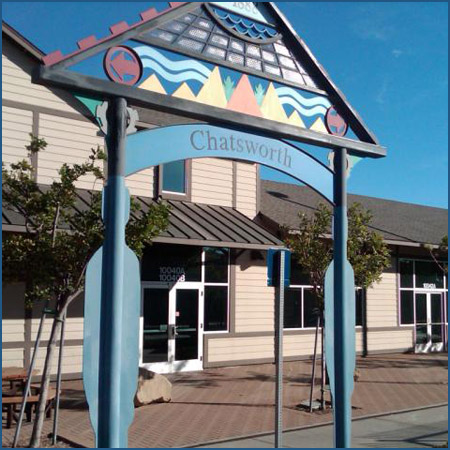
The Chatsworth Amtrak station consists of a platform with a shelter at the Chatsworth Transportation Center.
In the early 1990s, the municipal and county governments of southern California began an effort to establish and grow a commuter rail system. To initiate Metrolink service to Chatsworth in 1992, a platform and a few open-air shelters were constructed; soon thereafter, Amtrak relocated its stop there from the crossing of De Soto Avenue and the tracks further south. The Chatsworth Transportation Center, completed in 1996, was designed to resemble the community’s first depot. Local celebrity residents Roy Rogers and Dale Evans attended the station dedication that April.
Residents took part in a series of workshops to discuss the design of the new station and how it might fit into larger plans for the area. Santa Monica-based architect Aleks Istanbullu was hired to draw up plans for the transportation center, and he found inspiration through an uncle who loved model trains. Istanbullu was going through his uncle’s railroad magazines when he serendipitously came across a photo of Chatsworth’s first depot built in the 1890s.
Erected by the SP circa 1893, the structure was located about one block south of the current station and featured a two-story section from which extended a one-story freight room. The two-story section had numerous windows that allowed light into the interior where travelers found the station master’s office, a Western Union Telegraph office, and a waiting room. In rural locations such as Chatsworth, the upper floor housed an apartment for the station master and perhaps his family. The exterior was clad in wood clapboard, and on the second floor, the base was wrapped in decorative trim that created a grid of rectangles painted in a deep, contrasting color that made it stand out from the rest of the cladding.
A simple gabled roof covered the freight house and continued around the passenger depot in the form of a deep eave supported by curved brackets. This afforded passengers some protection from the elements when waiting outside. Historic photographs show that a large water tower was located near the station, as steam engines needed a constant supply of water to run smoothly. The station burned down in 1917, but a second depot had already been constructed in 1910. Similar in form to its predecessor, the SP demolished it in 1962.
Working off of these early images, Istanbullu and his team designed a station that echoes its lines and form, as well as material palette. The current depot stretches roughly 220 feet along the tree-lined platform. Most of the building is only a single story, but a central pavilion does rise to two stories and creates an airy waiting room filled with light. As in many depots of old, the pavilion displays a large clock face on its trackside gable that allows riders to keep abreast of the schedule. The wings are sheltered by a broad, hipped roof that stretches out to form a deep eave across the principle façade. Istanbullu used wood siding for the exterior cladding in direct reference to the 1893 depot; the cream colored clapboard is accented by trim painted a deep, rich brown. The 12,000 square foot structure cost $1.7 million and was funded through the following sources: $930,000 from the Los Angeles County Metropolitan Transportation Authority; $600,000 from the city of Los Angeles; and $250,000 from the state of California.
During the planning process, neighborhood residents expressed the desire that the depot house not just a waiting room or rail-related functions, but also community-based services. Therefore, Istanbullu incorporated space for a daycare center, small museum, café, and a few offices. The daycare facility was included because residents believed that more people would take the commuter rail if child care was easily accessible; Chatsworth is one of the few examples of an active rail station with a daycare center. The museum houses a collection of Western, transportation, and movie memorabilia that tell the story of Chatsworth’s past as a country outpost and then a residential haunt of early film stars. One of the office spaces is occupied by the area’s city council member and other rooms are available for community meetings. With all of these functions under one roof, the depot remains an active environment throughout the day.
In order to construct a new transportation center in Chatsworth, the city and county of Los Angeles, of which Chatsworth is a district, had to obtain a suitable site next to the tracks. Government officials, along with the Los Angeles County Metropolitan Transportation Authority, negotiated with Southern Pacific Railroad (SP) to purchase a 13 acre parcel that the railroad had wanted to turn into a lumber transfer yard. The city council contributed $5 million to the total $17 million price tag; the remainder of the funds was dedicated through county and state transit funds.
The California coast was first explored by Juan Rodriguez Cabrillo who worked for the Kingdom of Castile. In 1542 he claimed the region for Spain, but no settlements were planned; 60 years later the coast was mapped by Sebastián Vizcaíno. Although known by the Spaniards for more than 200 years, they did not establish settlements in California until the late 18th century when the Russian Empire began to take an interest in the area.
To secure the coast, King Carlos III authorized the creation of a chain of forts and missions to protect strategic sites that could be of future use to the Spanish Empire in North America. The first “presidio” or “fort” and mission complex was established at San Diego in 1769. That same year, the exploratory party of soldiers and Franciscan friars passed through the San Fernando Valley, but it was not until 1797 that a mission was established in the northeastern part of the valley.
The priests named the new mission “San Fernando Rey de España” after King Ferdinand III of Castile, and it was located about ten miles east of present day Chatsworth. The Franciscans worked toward the conversion of the region’s American Indians to Christianity, a stated goal of Spanish colonization. Each mission was supported by large tracts of land for agriculture and grazing that were worked by the friars and the converts. The majority of the San Fernando Valley once belonged to the mission.
American Indians were willingly or sometimes forcibly settled at the missions where the friars provided instruction not simply in religion, but also in crafts and skills such as tanning or woodworking. Those associated with Mission San Fernando Rey de España were referred to as “Fernandeño” (“of Ferdinand”). According to historic accounts, the Fernandeño, who called themselves Tataviam, meaning “people facing the sun,” were but one of three American Indian peoples to populate the area encompassing present day Chatsworth. The others were the Tongva, or “people of the earth,” who the Spanish referred to as “Gabrieliño” because of their association with the nearby Mission San Gabriel, and the Chumash, or “bead makers/seashell people” who occupied areas to the west of Chatsworth.
All three groups inhabited territories stretching from the coast to the mountains. The Tongva and Chumash were among the few American Indian peoples to navigate the coast in canoes that were water proofed with pine pitch or tar. When Cabrillo sailed into the region, the Tongva and Chumash went out by canoe to observe the explorer.
Chatsworth is located near an important pass through the Santa Susana Mountains separating the San Fernando and Simi Valleys. Early American Indian trails traversed the area, and they were then used by the Spanish as a way to travel between Mission San Fernando and Mission San Buenaventura to the northwest. Its location was identified from a distance, marked by a rocky sandstone outcropping known as Stoney Point. This spot, with its caves and overhangs, was the location of a Tongva settlement that welcomed trade with the Tataviam and Chumash.
In the 1850s, the path was widened for stagecoaches traveling between Los Angeles and San Francisco, and its treacherous grade earned it the name “Devil’s Slide.” When descending the trail, passengers often had to get out of the wagon and walk; the horses or mules were sometimes blindfolded to keep them calm. Close to the pass, a relay station was established where tired horses could be traded out for rested animals before drivers made the trip over the rocky road.
The priests and American Indians at San Fernando grew grains and beans and raised livestock, and the mission was also noted for its red wine. Following Mexico’s independence from Spain in 1821, the missions were secularized and many of the buildings and land holdings were sold off to private owners, who created large “ranchos” or ranches used primarily for sheep and cattle grazing. Many of the ranchos survived into the American period following the in the Mexican-American War of 1845-1848 and the resulting cession of California and much of the Southwest to the United States.
Modern Chatsworth sits on land that once belonged to a number of ranchos, but the great majority was part of Rancho Ex-Mission San Fernando. Sold to Spaniard Eulogio de Celis in 1846, the 116,000 acre estate encompassed most of the valley. A decade later, the rancho was divided between de Celis and Andres Pico, brother of a two-time Mexican governor of California; the dividing line roughly followed present-day Roscoe Boulevard, and de Celis retained the upper half that includes Chatsworth.
When Eulogio de Celis died in 1869, his 56,000 acre property was sold in 1874 to a group of northern Californians, including State Senator Charles Maclay, shoe manufacturer George Porter, and Benjamin Porter. Needing financial assistance to cover the purchase price of $117,000, Maclay turned to his friend Leland Stanford — who happened to lead SP. Maclay received the money and a tip about a future rail line that was to run through his portion of the land in the east. He eventually established the town of San Fernando while Benjamin Porter stuck to wheat farming on the western acreage.
A few years prior to the Porter purchase, a number of families had claimed homesteads in the area around the stagecoach relay station. In 1888, Benjamin Porter sold part of his property to a land development company and that same year a subdivision map was filed with Los Angeles County for “Chatsworth Park,” a farming village consisting of ten acre parcels; five years later this plan was augmented with a vision that included a train station and commercial district. Chatsworth was named after the manor house of the English Duke of Devonshire, giving the small town allusions to grandeur.
In 1876 the SP opened its tunnel through the Newhall Pass northwest of San Fernando, just as Leland Stanford had promised to Charles Maclay. This became the main route between Los Angeles and San Francisco, and the stagecoach traffic through Santa Susana Pass lessened. In 1893 a SP branch line crossed the valley to Chatsworth which acted as the terminus until 1904 when the one-and-a-half mile Santa Susana tunnels were completed through the old pass. This path was easier than the Newhall route and eventually Chatsworth found itself on the main “Coast Line” between Los Angeles and San Francisco. The construction of the Santa Susana tunnel took six years and attracted many new settlers to the small agricultural town. Chatsworth, located 31 miles northwest of downtown Los Angeles, decided to join the city in 1920 in order to hook up to the municipal water system.
As the 20th century progressed, Chatsworth’s wheat fields and lemon, orange, and fig trees were slowly replaced by new residential developments. Hundreds of movies were filmed in the hills whose beautiful forms were used to represent foreign planets, far away deserts, and generic “Western” landscapes. Famous television series such as The Lone Ranger and Bonanza were shot at the Spahn and Iverson Ranches located north of the Santa Susana Pass. With this exposure and the area’s proximity to Hollywood, early film and television stars moved to Chatsworth to take advantage of its large lots and horse and bridle trails. Lucille Ball and Desi Arnaz owned a five acre ranch called Desilu where they lived while working on I Love Lucy. Many of the equestrian paths are still used today, making Chatsworth a rather unique Los Angeles neighborhood.
Chatsworth is noted for the extensive parkland nestled in the mountains around its northern and western edges. Santa Susana Pass State Park is popular for its trails that welcome hikers, mountain bikers, and equestrians. Visitors can view the rail tunnel that passes through the middle of the site, and many hikers admire the flora and fauna such as laurel sumac, buckwheat, and wild lilacs, and coyotes and ringtails. The Homestead Acre features the Hill-Palmer Cottage, a 1913 bungalow that is the only remaining homestead structure in the San Fernando Valley. The acre is now a park and the house is maintained by the local historical society. Every October, the society puts on Pioneer Day, a celebration of Chatsworth past and present.
The Pacific Surfliner service is primarily financed through funds made available by the State of California, Department of Transportation, and is managed by the LOSSAN Joint Powers Authority.
Features
- ATM not available
- No elevator
- No payphones
- No Quik-Trak kiosks
- No Restrooms
- Unaccompanied child travel not allowed
- No vending machines
- No WiFi
- Arrive at least minutes prior to departure
Baggage
- Amtrak Express shipping not available
- No checked baggage service
- No checked baggage storage
- Bike boxes not available
- No baggage carts
- Ski bags not available
- No bag storage
- Shipping boxes not available
- No baggage assistance
Parking
- Same-day parking is available; fees may apply
- Overnight parking is available; fees may apply
Accessibility
- No payphones
- No accessible restrooms
- No accessible ticket office
- No accessible waiting room
- No accessible water fountain
- No high platform
- No wheelchair
- No wheelchair lift
Hours