
(CUM)
Known as Maryland's “Queen City,” Cumberland was an early gateway to the West. Today, it is a bustling arts center and popular stopover for cyclists using the trail network between Pittsburgh and Washington, D.C.
- Facility Ownership: CSX Transportation
- Parking Lot Ownership: N/A
- Platform Ownership: CSX Transportation
- Track Ownership: CSX Transportation
Denise Miller
Regional Contact
governmentaffairsnyc@amtrak.com
For information about Amtrak fares and schedules, please visit Amtrak.com or call 1-800-USA-RAIL (1-800-872-7245).
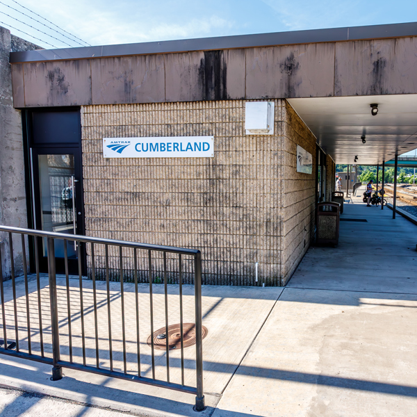
As Amtrak trains pull into Cumberland, a town spread among the foothills of the Appalachian Mountains and dotted with church steeples and a multi-spired courthouse tower, little do most passengers realize that they are entering one of the nation’s early transportation hubs and a prime “Gateway to the West.” Passengers at Cumberland use a modest facility located about seven blocks east of Canal Place, a popular spot that is home to the Chesapeake and Ohio Canal Visitor’s Center, the Western Maryland Scenic Railroad, and various shops and offices.
Constructed in the late 1970s, the station is typical of those built during Amtrak’s first generation of service. The exterior of the one-story building is covered in textured, beige concrete masonry units and the waiting room is flooded with natural light that enters through dramatic floor-to-ceiling windows that also allow a view of trackside activity. A deep porch shelters passengers from inclement weather while they wait on the platform. Although the station is unstaffed, there is a caretaker who opens the waiting room before the arrival of the morning and evening trains.
In early 2010, Cumberland received $100,000 from Maryland’s Community Legacy Program, which provides local governments with funding for projects aimed at strengthening communities. The funds were used to improve the area around the Amtrak station by replacing the sidewalk, upgrading the lighting, and implementing other safety and security measures. The next year, the city used the Community Legacy funds as a match for a $173,000 Transportation Enhancements (TE) grant. Made available through the Federal Highway Administration, the TE grant was distributed by the Maryland Department of Transportation. The city used the money to continue improvements to the station area, including repaving a walkway, adding station signage, installing information kiosks and upgrading decorative planters for flowers and shrubs. The city envisioned the station as a place where hikers and cyclists from the Great Allegheny Passage Trail and the C&O Canal towpath trail could unload their bikes and learn about local sites, restaurants and shopping to further encourage tourism.
If Baltimore was Maryland’s “King City” in the nineteenth century—the state’s only major port and a prime industrial center—then Cumberland was certainly the “Queen,” a designation that led to its moniker of “Queen City.” The bonds between the two towns were strengthened from the earliest days as they were united by both an early highway and a railroad. Nestled among the hills of the eastern Appalachian Mountains at the confluence of the north branch of the Potomac River and Wills Creek, Cumberland guarded a very strategic spot in the extensive mountain chain: Cumberland Narrows. Over thousands of years Wills Creek had cut a slender water gap through the mountains to create a pass that road and railroad engineers later coveted as they envisioned transportation corridors that would open up the Northwest Territories and provide access to the Ohio River Valley.
Influenced by this topography, Cumberland was established as a seasonal trading post by Christopher Gist of the Ohio Company, a group of Virginians interested in land speculation beyond the Appalachians. Trappers and fur traders came to the post to barter with the area’s Shawnee people and a storehouse was erected. A few years late in 1754, a small fort was constructed at the meeting point of the two waterways and named after the son of the reigning King George II—the Duke of Cumberland.
Fort Cumberland would be an important post during the French and Indian War of 1754-1763, fought between the British and French for control of the Ohio Valley and the lands beyond the mountains. A young Colonel George Washington retreated to Fort Cumberland in 1754 after a failed attempt to take the French position at Ft. Duquesne, now the site of Pittsburgh. The next year, General Braddock used the fort to launch another ill-fated campaign to take Ft. Duquesne—a journey from which he would not return. As commander of the Virginia troops after Braddock’s death, Washington spent much time at Cumberland, and a log cabin that served as his headquarters is the oldest surviving structure in the city. After the war, the fort was abandoned and fell into disrepair.
The small settlement received a boost in 1789 when it officially became a city and the new Allegany County seat. In time, memories of the fort faded as the town grew up around and on top of it. As a young city, Cumberland received a lucky break in 1806 when it was named as the eastern terminus of the National Road, one of the first improved highways backed by the new federal government. Also referred to as the “Cumberland Road,” the highway eventually connected the town with Vandalia, Illinois; a later extension took the road to Baltimore. In the Cumberland area, the National Road followed the path of Braddock’s Road, so named because Braddock’s troops had traversed it during the French and Indian War. The rough road had been partially cleared by the Ohio Company, but it followed earlier American Indian trails running along the mountain chain.
The highway transformed the city into an important midpoint between the eastern ports and the American interior, but the roadbed required constant maintenance. A more reliable transportation route between the East Coast the west was vital for merchants of the Mid-Atlantic region, as the newly completed Erie Canal in New York and the evolving Main Line of Public Works in south central Pennsylvania threatened to give a marketplace advantage to merchants from those regions who would have direct access to the nation’s major ports at New York and Philadelphia. Entrepreneurs in Maryland turned to two new options: canals and railroads.
With the benefit of hindsight, it seems like the railroad would have been the obvious choice, but early investors had more faith in canals whose technology was understood and had been improved over many centuries. Early experimental railroads often used wood rails or weak metal versions and the track bed lacked now-common features such as ballast, resulting in a bumpy ride. The C&O Canal broke ground in 1828 outside of Washington, D.C., and was to connect the capital on the Potomac with the headwaters of the Ohio River in western Pennsylvania. Slow progress and lack of financing only dug the canal to Cumberland in 1850, where building stopped. The city donated land for a terminal boat basin located along Wills Creek near its confluence with the Potomac River.
The state of Maryland has often been called the “cradle of American railroading,” and the Baltimore and Ohio Railroad (B&O) was the country’s first major common carrier. The B&O eventually connected the port of Baltimore with the cities of the Northeast and the far Midwest; in fact, it was the first railroad to cross the Appalachians. Chartered in Baltimore in 1827, the groundbreaking took place a year later; in attendance was Charles Carroll, then the last living signer of the Declaration of Independence and scion of a major Maryland family. Although the first passenger carriages were drawn by horses, by the time the B&O reached Cumberland in 1842, improved steam engines were the norm.
From Cumberland, the B&O’s branch lines transported coal, iron, and limestone to Baltimore while manufactured goods for early pioneers came west on the return trip. The canal was early eclipsed by the railroad, which was faster and more efficient, but the waterway did survive until the 1920s as a transporter of bulk goods such as coal, lumber, and flour which were not on time-sensitive delivery schedules. At maximum speeds of five miles per hour, the 184 mile journey between Cumberland and Washington, D.C., took roughly a week to complete. Coal-hauling railroads brought the “black gold” to the canal wharf where it was then transferred to the boats. The importance of the B&O and the C&O to the national transportation system was highlighted during the Civil War; located in a border state, the two operations were a tempting target for Confederate espionage. Accordingly, the Union Army stationed 3,000 troops at Cumberland to guard these assets, as well as the coal mined in the area which powered Union industry.
With road, canal, and rail connections in place by 1850, Cumberland flourished as a manufacturing center, and was particularly known for the industrial, household, and decorative glass made by thirty different companies that in 1920 employed more than 1000 residents. Good local sand deposits supplied the industry with an essential raw material while the railroads carried the finished product across the country. After a major flood in 1889, the C&O Canal was in financial ruin and went into receivership under the B&O which standardized operations.
By the 1890s, the five railroads running through Cumberland employed 2000 workers; because the city was on the B&O’s mainline midway between Baltimore and Chicago, the railroad built a maintenance and repair complex on the south end of the city starting in the 1870s. The rolling mill employed 750 men who manufactured 2,500 tons of steel rails every month to accommodate the railroad’s growth. In time, the complex included a thirty-one stall roundhouse and shops where heavy repair and service could be undertaken on steam locomotives. This period of growth made Cumberland the second most populous city in Maryland.
Today the old B&O shops belong to CSX Transportation and are still a major center for light to medium locomotive repair work. At the CSX classification yard, freight cars are sorted or “classified” to create new trains according to destination. This is a “hump yard,” meaning that cars are pushed over a “hump” and then gravity carries them down to the appropriate track. The cars are ordered on the train so that they can be easily distributed at junction points and other railroad connections.
The B&O also constructed a combination station and hotel in Cumberland for which the city became famous; not only was it rare to have a station in a hotel, but the facility was also noted for its luxury. The Queen City Hotel served passengers traveling between the East Coast and the Midwest. Before dining cars were common, passengers had to detrain in order to have a meal; the frescoed dining room at the Queen City could hold 400 diners and often doubled as a ballroom. Hotel rooms were also available for those wishing to stay overnight since the city was the junction point for the lines northwest to Pittsburgh and west to the Ohio River.
Located in the mountains, Cumberland became a summering spot for the Baltimore and Washington elite who could afford to move their households during the muggy, humid months. In this regard, the B&O was on the forefront of tourism development; decades later, the railroads of the American West would become famous for their chains of hotels located close to natural wonders such as the Grand Canyon.
The Queen City Hotel consisted of a two story central section with a prominent octagonal cupola; it was flanked by four story wings on either side with hipped roofs. Constructed of brick, the structure had Italianate detailing such as window hoods and brackets at the cornice line. Trackside, the ground floor façade featured a ten-and-a-half foot deep piazza with extensive floral-inspired wrought iron decoration reminiscent of that found in the French Quarter of New Orleans. The metalwork was considered some of the most beautiful outside of that southern city and it set the building apart from other area hotels.
Surrounding the structure were three acres of landscaped grounds including a fountain and mature tree specimens. The Queen City Hotel quickly became the center of Cumberland’s social scene, hosting the annual New Year’s Dance as well as countless wedding receptions and honeymoon stays. By the mid-twentieth century, the building had fallen into disrepair and only portions of it were used for the station and railroad offices. Listed on the National Register of Historic Places in 1971, it was torn down by the railroad the next year. The rapidity of the destruction invigorated a local preservation movement.
The other key railroad to enter Cumberland, aside from coal-hauling lines, was the Western Maryland Railroad (WM). Although the WM was not a major force in Cumberland until the early twentieth century, it had been chartered by the state in 1852. Progress was slow until it was purchased by the Fuller Syndicate in 1902; this group was part of railroad executive George Gould’s attempt to create a transcontinental railroad by assembling smaller lines and building anew where needed. With an influx of capital, the WM reached Cumberland in 1906 and then proceeded to build north into Pennsylvania where it connected with the Pittsburgh and Lake Erie Railroad at Connellsville in 1912 to gain access to Pittsburgh. Regarded by its admirers as the “Wild Mary,” the WM became known for its great engineering works required to cross the mountains, including impressive tunnels and bridges.
Cumberland was a major stop on the Western Maryland because the city was a chief destination for the railroads that served great portions of West Virginia and its rich seams of coal. Touting its new-found status, Cumberland gained a new WM station in 1913 designed by C.M. Anderson. The depot was built on the north end of the old canal basin which had been filled in as the canal declined in importance. The new station was three stories plus an attic enclosed under a hipped roof pierced by dormers; elevated tracks on the east side of the building placed the platforms at the level of the second floor.
The first floor base of rusticated dressed stone supports two additional stories constructed of red brick. A prominent modillioned cornice and frieze wrap around the structure, and visually tie into the base through the use of the same material. The façade is rhythmically divided into equal bays composed of a segmented arch at the base topped by a two-story, recessed segmented arch on the brick portion of the façade. The station served not only its namesake and associated coal lines purchased by the Fuller Syndicate, but also the Pennsylvania Railroad which provided through service to Washington, D.C., and New York City.
Closed in 1958, the station underwent a series of renovations in the 1990s and is today once again a bustling center in downtown Cumberland known as Canal Place. Although the WM trackage was eventually subsumed into CSX through a series of mergers and purchases in the late twentieth century, a portion is now operated at the Western Maryland Scenic Railroad which makes a roughly ten mile, three-and-a-half hour excursion run to nearby Frostburg. The vintage locomotives and cars pass through the Cumberland Narrows and beautiful mountain scenery especially popular in fall when the trees are in a riot of color.
The WM station also acts as the northern terminus of the C&O Canal, which is now a national park stretching 184 miles down to Washington, D.C. Exhibits and an information center on the ground floor of the station describe the canal’s historic, scenic, and recreational features. Where the canal ends, the Great Allegheny Passage picks up. The hiker-biker path connects Cumberland with downtown Pittsburgh via abandoned rail rights-of-way. The avid cyclist or walker can cover the distance between Pittsburgh and the national capital while also exploring the towns that line the path and tell the story of American railroading and canal building. In fact, the WM station and the surrounding blocks form Maryland’s first state heritage area, created in recognition of the transportation history and technology represented by the railroad, canal and National Road and their impact on the region’s development.
In addition to the canal visitors’ center and the Western Maryland Scenic Railroad headquarters, Canal Place consists of shops, offices, and an outdoor plaza for public events such as a summer music series. In September, CanalFest/RailFest brings in visitors from near and far to celebrate the city’s transportation heritage. Events include live music, children’s activities, train excursions, food vendors, and fireworks. The most anticipated spectacle is the “train pull” sponsored by the Allegany County Sheriff’s Office. Teams of twenty compete to move a 250 ton locomotive—the fastest team wins, and all the money raised goes to charity.
Building on its historic heritage, Cumberland has steadily worked over the last decade to broaden its economic base and accommodate tourism. Wandering north of Canal Place, the visitor will find the Queen City Transportation Museum whose core collection was assembled by county resident James Thrasher. Exhibits draw attention to the National Road, the Queen City Hotel and Station, and Cumberland’s Baltimore Street, the city’s historic commercial center. Much of downtown is an historic district and architecture buffs fall in love with the diverse structures that line the streets and encompass just about every major architectural movement of the last 150 years. Crossing Wills Creek, the elaborate houses on Washington Street once sheltered the barons of local industry such as the president of the C&O Canal.
Features
- ATM not available
- No elevator
- No payphones
- No Quik-Trak kiosks
- No Restrooms
- Unaccompanied child travel not allowed
- No vending machines
- No WiFi
- Arrive at least minutes prior to departure
Baggage
- Amtrak Express shipping not available
- No checked baggage service
- No checked baggage storage
- Bike boxes not available
- No baggage carts
- Ski bags not available
- No bag storage
- Shipping boxes not available
- No baggage assistance
Parking
- Same-day parking is available; fees may apply
- Overnight parking is not available
Accessibility
- No payphones
- No accessible restrooms
- No accessible ticket office
- No accessible waiting room
- No accessible water fountain
- No high platform
- No wheelchair
- No wheelchair lift
Hours
Station Waiting Room Hours
| Mon | 09:10 am - 10:20 am 06:40 pm - 07:40 pm |
| Tue | 09:10 am - 10:20 am 06:40 pm - 07:40 pm |
| Wed | 09:10 am - 10:20 am 06:40 pm - 07:40 pm |
| Thu | 09:10 am - 10:20 am 06:40 pm - 07:40 pm |
| Fri | 09:10 am - 10:20 am 06:40 pm - 07:40 pm |
| Sat | 09:10 am - 10:20 am 06:40 pm - 07:40 pm |
| Sun | 09:10 am - 10:20 am 06:40 pm - 07:40 pm |