
Antioch-Pittsburg, CA (ACA)
Located at the confluence of the San Joaquin and Sacramento rivers, Antioch is set against a backdrop of golden hills dotted with dark green oaks and scrub.
- Facility Ownership: City of Antioch
- Parking Lot Ownership: N/A
- Platform Ownership: City of Antioch
- Track Ownership: BNSF Railway
Alex Khalfin
Regional Contact
governmentaffairsoak@amtrak.com
For information about Amtrak fares and schedules, please visit Amtrak.com or call 1-800-USA-RAIL (1-800-872-7245).
The Amtrak stop in Antioch–Pittsburg is a modern shelter beside the platform. The location is also served by the county’s Tri Delta Transit, which connects to the BART station in Pittsburg, the next town to the west.
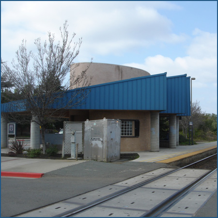
Coming into service in December 1990 as part of Contra Costa County’s Tri Delta Transit, Antioch’s Tri Delta Depot has an unusual asymmetric teal-colored metal roof that presents a large-scale saw-tooth horizontal profile on the platform side of substantial thickness, and thins toward a smooth edge on the parking lot side. Concrete pillars support the roof of this partially open-sided pavilion and sheltered concrete benches provide resting places for travelers. A concrete-sided enclosure lightened with glass-block windows provides a wind break as well. A plaque on the structure declares that funds were provided by the California Transportation Commission, East Contra Costa County Transit Agency and Antioch Development Agency.
Antioch and its close neighbor to the west, Pittsburg, are sited at the entry to the delta region east of San Francisco Bay, at the confluence of the San Joaquin and Sacramento Rivers and north of Mount Diablo. The towns are set in an arable region against a backdrop of golden hills dotted with dark green oaks and scrub. While the region had been populated for thousands of years by a variety of Native American tribes, European-descended settlers only began to arrive after the War of Mexican Independence. At that time there were several local Spanish families that had been given grants and worked their ranchos into the 1830s and 1840s. Land along the rivers and up to the higher altitudes proved good for farming wheat and growing wine grapes, olives, and fruit as well as for livestock husbandry.
Mount Diablo, which is visible from the hills of Berkeley and Oakland, is a familiar feature on the Bay Area skyline, and is the centerpiece of the Mount Diablo State Park. The triple peaks were considered to be sacred territory to many of the local Native peoples: according to Miwok and Ohlone mythology, it was the point of creation. The current name is said to commemorate the escape of several Chupcan natives from Spanish soldiers into a nearby willow forest, where they utterly vanished, eluding their pursuers—who thus named the area for this suspicious event, Monte de Diablo.
The first American settler recorded was a Dr. Marsh, who arrived in 1847. He later hosted the brothers Reverend Joseph H. and W.W. Smith and their families, who arrived at the nearby homestead known as New York of the Pacific or New York Landing, which was approximately in present-day Pittsburg. The doctor gave them ten acres each near the river’s edge, advising them to raise livestock, and this is where they broke ground on Christmas Eve, 1849. California’s annexation by the United States and the discovery of gold in the state soon brought more settlers. By the next fall, new families were arriving at what was then called Smith’s Landing. On July 4, 1851, at the holiday picnic, the residents of the growing settlement considered what to call their new home. In honor of his deceased brother, Reverend Joseph Smith, W.W. Smith suggested they give it a biblical name, and so Antioch was chosen.
As early as 1845 and shortly before the California Gold Rush, reports came of good quality coal discovered in the vicinity of San Pablo Bay, but it was rancher William Israel who, around 1859, exposed a vein of coal while cleaning out a spring located six miles south of Antioch. From the 1860s into the beginning of the 20th century, the nearby Mount Diablo coal field was the largest and most extensively mined coal deposit in California: an estimated four million tons of coal was extracted from this area. Twelve coal mines were developed there, and while composed of geologically young, relatively poor-quality bituminous coal, the Mount Diablo coal field nonetheless provided a major energy source for California, powering factories, ferries, steam ships and mills as well as heating homes.
Francis Somers and James T. Cruikshank discovered the Black Diamond Vein on December 22, 1859. Several mines were opened in the area, with names conjuring industrial cities of the east—Manhattan, Eureka, Union, Independent, and Pittsburg. Altogether, three steeply dipping veins were worked in the Mount Diablo field: the Clark, Little, and Black Diamond. Five mining towns quickly sprang up south of Antioch: Nortonville, Somersville, Stewartville, West Hartley and Judsonville.
In 1868, a short rail route opened from Nortonsville and Somersville up to Pittsburg Landing (now the town of Pittsburg). Pittsburg Landing, sometimes called “Black Diamond,” became the deepwater shipping point on the river for the Somersville mines, and was sited two miles east of the New York Landing on the river. The name of the town was proposed in 1909 in honor of its industrial potential as well as its relationship with the Columbia Geneva Steel Company, and changed from “Black Diamond” in 1911. Altogether, there were three coal mine railroads that came up to present day Pittsburg and Antioch. Pittsburg’s Southern Pacific (SP) depot once stood at the remnant of the Black Diamond Coal and Railroad Company line where it crossed the SP; the depot was built in 1878 and burned in 1980.
In the 1880s, the Black Diamond Company of San Francisco opened a mine in the Green River region of Washington Territory which extracted higher-grade coal. Due to competition with the Washington mines and its own veins running out, by 1885, the California Black Diamond mines began to close down, and many of the predominantly Welsh miners from Nortonville left for Washington State. The towns of Nortonville, Somersville, Stewartville, West Hartley and Judsonville are completely gone now, the local ranchers and builders having scavenged every brick and board for use elsewhere over the years, and the region is left with many mine openings dotting the hills—dangerous for unwary hikers and explorers.
A belt of sandstone also ran in the Mount Diablo foothills, which was mined in the 1920s at the deserted Nortonville and Somersville townsites. The Somersville mine supplied sand used in glass making by the Hazel-Atlas Glass Company in Oakland, while the Nortonville mine supplied the Columbia steel works with foundry (casting) sand. Competition from Belgian glass and the closing of the steel foundry ended the sand mining by 1949. Altogether, more than 1.8 million tons of sand had been mined.
In 1972, the East Bay Regional Park District acquired the Black Diamond mine lands, and today, visitors to the Black Diamond Mines Regional Preserve may tour the Rose Hill Cemetery in former Somersville and the Hazel-Atlas sand mine, and learn more at the visitor’s centers. Camping and hiking are also popular in the region, as this semi-arid region is home to varieties of rare birds and flora.
Offshore near the Antioch marina visitors will find the low, bushy, and curiously rusty “Solano Island” which is the wrecked remains of one of the largest train ferries in the world. Four hundred feet long and 100 wide, the Solano worked from 1879 to 1930 between Port Costa and Benicia; when it was decommissioned, it was sunk to form a breakwater at Antioch. The deep waters it once carried whole trains across are now crossed by the Benicia-Martinez (Carquinez) railroad drawbridge.
In 1889, Antioch added papermaking to its industries, served directly by the Atchison, Topeka, and Santa Fe Railroad, but these mills are now closed. Antioch today is primarily a suburb for the cities to its west, as is much of Contra Costa County. However, its citizens are seeking to bring businesses to them, as their cost of living is somewhat lower than the bay-ward cities.
The Gold Runner service is primarily financed through funds made available by the State of California, Department of Transportation, and is managed by the San Joaquin Joint Powers Authority.
Platform with Shelter
Features
- ATM not available
- No elevator
- No payphones
- No Quik-Trak kiosks
- No Restrooms
- Unaccompanied child travel not allowed
- No vending machines
- No WiFi
- Arrive at least 30 minutes prior to departure
Baggage
- Amtrak Express shipping not available
- No checked baggage service
- No checked baggage storage
- Bike boxes not available
- No baggage carts
- Ski bags not available
- No bag storage
- Shipping boxes not available
- No baggage assistance
Parking
- Same-day parking is available; fees may apply
- Overnight parking is available; fees may apply
Accessibility
- No payphones
- Accessible platform
- No accessible restrooms
- No accessible ticket office
- No accessible waiting room
- No accessible water fountain
- Same-day, accessible parking is available; fees may apply
- Overnight, accessible parking is available; fees may apply
- No high platform
- No wheelchair
- Wheelchair lift available
Hours